Aberporth to New Quay

6th October 2018

Day two of our double-header, and I make no apology that today will be full of photographs, as this has to be one of the most stunning sections of coastal path. It needs to be though or people wouldn’t attempt it, as it is single day with the biggest climbs of any – over 780 metres if the guide book is to be believed.

So we are planning for this walk to take all day, and Bethan arrived at 9.15 to get us to the start point (thank you Bethan again). The early start is OK though as I have been promised breakfast when we get to Tresaith. I am not sure how Bonnie’s little legs will cope with all the hills today either.

Looking down on Aberporth

The first part of the walk is on a new tarmac path, and you walk past several houses which have been converted from train carriages – explains why we couldn’t get a train to our start point today!!

A carriage with a view

The walk was already teasing us with the views ahead of us.

Just a part of what is still ahead of us today

We arrived at Tresaith at just after 10, only to find the cafe shut and the only pub stopped serving breakfast at 10.

Tresaith ahead of us

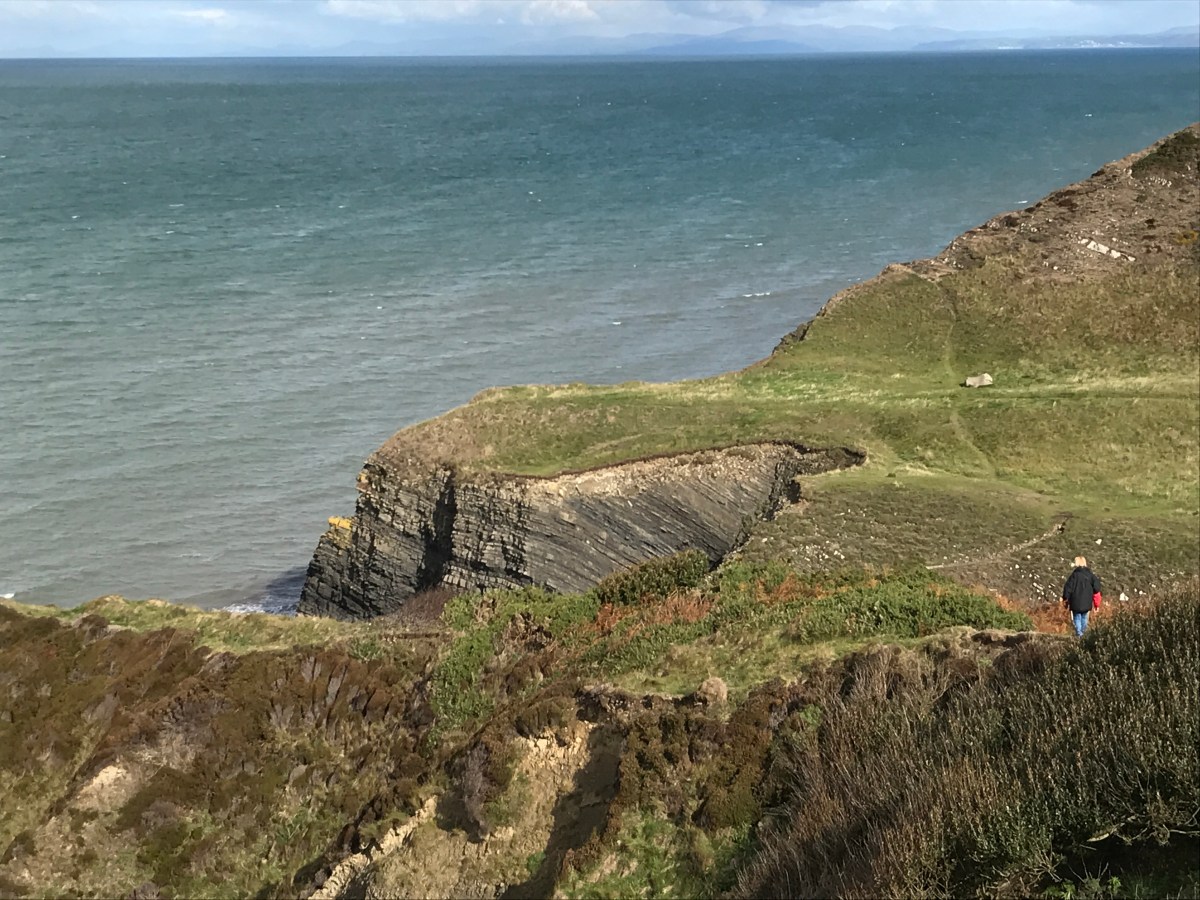
So we soldiered on up the hill out of Tresaith, and towards Penbryn Beach.

Penbryn Beach
The view behind us and the hill we were walking up

Penbryn also took us in land slightly to get past a river, and we decided to stop in the wooded glen, complete with ferns, to have our breakfast – which was actually half of our lunch (a bit early).

A waterfall by breakfast

We then climbed up the other side of the wood and found ourselves in a National Trust car park, complete with a tea room.  The air did turn rather blue at this point!!

This tea-room looks nice – if doing this route then make sure you plan a visit to it!!

The views behind us got better and better as we got higher and higher.

And ahead of us now was Carreg-y-ty with it’s sandy cove.

Bonnie leads the way to Carreg-y-ty
Come on in, the water looks lovely

It looks like there is a little door inside

The view ahead then got better still as we approached Ynys Lochtyn, which is used as the main picture to advertise the Ceredigion coastal path.

The next landmark on the way to Ynys Lochtyn was Llangrannog, the village rather than the activity centre that kids stay in. We had been told of a lovely coffee shop on the sea front, and it didn’t disappoint. At this point we were 5 miles in and around 120 flights of stairs, so we still had a way to go.

Llangrannog
Sharon makes friends with St Carannog who founded the first church in the area
The beach at Llangrannog
A close up of Ynys Lochtyn

The coast line ahead still showed a lot of undulations, with Cwmtydu now the distant part.

One last glimpse back to Ynys Lochtyn

And then out of no-where comes the Llangrannog activity centre with ski slope and go karts

The climbs seemed to get steeper and steeper, and New Quay still wasn’t in sight, and ahead was the worst climb of them all, cut into the hill side.

You can just make out the path ahead of us

And then, not since our first walk nearly 4 years ago in Chepstow, Sharon once again uttered the famous words “That’s a pretty sheep”.  And, to be fair, it was.

Who’s a pretty girl then

The next big drop through a forest took us into Cwmtydu, and a welcome, if somewhat expensive ice-cream stop

It’s a long way down

We didn’t have time to stop at the tractor table
Ice-cream on the go for us
Some sort of smuggler cave maybe at Cwmtydu

We still had a massive climb to go, and then from the top the view looked like this, where is New Quay?

Another descent followed, and on a bridge in the middle of no-where was this….

A bit late!!

I could have done with that a few hours earlier!!

Our final climb
Sharon and Bonnie lagging behind, and Sharon looks like she is puffing a bit

After all the dangerous walking it was a surprise to see this warning sign right at the end, but we did follow the safer route.

Which finally gave us a glimpse of New Quay

New Quay over the hedge
The harbour wall

What a welcome sight that was and what a view

The route then took us down through the town, past houses, and the harbour, ending our day with the walk out of New Quay to the caravan site.

And we are back home

Strava records it as 14.6 miles and 4,148 feet of height (which is 1,264 metres).  This is higher than walking up Snowdon.

What a bumpy ride

And that was our weekend done – 27.2 miles in total, making a grand total of 430.9 miles walked and 443.3 miles to go. One more day of walking and we should be halfway around the coast.

New Quay to Llanrhystud

6th October 2018

Our last walking weekend of the year – and also our first since May (which is very remiss) and we got off to a delayed start as the weather was so bad on Friday and on Saturday morning, so only 2 walks this weekend, but they will have lovely scenery.

Today we are walking the 13 or so miles from New Quay (where we have hired a static caravan) to Llanrhystud to join up with this previous walk. We chose this way as it is relatively flat (compared with the walk we are saving for tomorrow) and we should be able to complete it in an afternoon rather than having an all-day adventure.

You can see the sea from our caravan!

We headed down to the beach and walked along till a river meant we had to head inland.

The view back to New Quay
New Quay beach below Quay West Haven park


The view even further back towards New Quay
The hills ahead of us


Some stunning landscape around Craig Ddu
The beach below Cwm Clifforch

And before we knew it our lunch-spot of Aberaeron was right in front of us.

The coastal path led down, through a forest, over a bridge and past an orange roman style house, complete with horse statue in the garden, to the town of Aberaeron.

It’s not moving
Sharon is not afraid of heights

We met up with Bethan (our taxi driver for later as buses are infrequent) and bribed her with pancakes and nutella, and then set off around the lovely harbour and back to our walking.

The walk now was mostly flat for the rest of the afternoon, which was exactly what we needed to keep the pace up and get to the end before 5.30.

That’ll be us

Just before Llanon we got a little bit lost and had to ask for directions. The alternate Blue route goes in land to Llanon itself to get over the river, but the red route allows for you to do a bit of stepping stones (I did OK!!) over the river and then walk along the beach to the second tower and then the paths rejoin.

The tower to get off the beach

At this point we stopped to collect some driftwood for future projects, but it did look more like Sharon had been to the bakery!!

Baguettes anyone?

We then had to weave through the small town of LLansantffraed, and over a bridge next to the church of St Brides before heading past four old lime kilns, used historically to burn limestone to spread on the fields to make them more fertile and improve drainage.

Lime Kilns

Then a stop for a coffee and cake on the beach watching the waves hit the shore from the strong wind….

and then the coastal path takes you up a long straight road towards the main road.

It’s me again – but look at that sky

And you arrive at the entrance to the campsite which marked the end of the previous walk.

The coastal path would then head back into the camp site and up the hills to Aberystwyth, but for us that is the end of the day, and a moment to relax before Bethan arrives to take us back to the campsite. 12.6 miles in total and around 450 metres of height gained today. Time for dinner before tomorrow’s adventures.

%d bloggers like this: