Moylgrove to Newport Parrog

4th May 2019

Today is another day where we have already done part of the walk – so although in the book the walk is from St Dogmael’s to Newport (Parrog) we have already walked from St Dogmael’s to Moylgrove (with the kids, well the other way from Moylgrove to St Dogmael’s actually) so today is now slightly easier.

We drove to Parrog car park and waited for the bus. This has to take the record for parking close to where the bus picked us up from. This bus only runs on a Thursday and Saturday in low season, and adds a 3rd day per week from the end of May.

Yes that is the car outside the bus window
And a first for Bonnie – her own ticket

The bus dropped us, and quite a few other walkers, in Moylgrove village and we knew it was about a mile to get to the coast. The others all set off while we were still getting ourselves sorted and it took a while for us to find the woodland path to get to the coast but it was a lovely walk with a stream running below us and plenty of spring flowers.

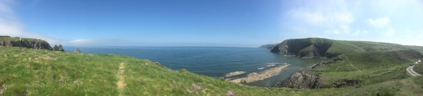
Then suddenly we appeared at the familiar sight of Ceibwr Bay and the walk proper could begin.

Ceibwr Bay

The first landmark is Witches Cauldron, which is a collapsed sea cave.

Note the arms in shadow – I wasn’t getting any closer to the edge so had to reach up for the picture

A little further along the path dropped to sea level but on the left was a beach with the tide going in and out right underneath us.

Of course, after going down we had to then climb the other side, for some further magnificent views including Bwn Bach which is a small perfectly formed archway and then along the top of Traeth Cell-Howell.

We reached a spot where we could see a further drop ahead of us and then a massive set of steps, and decided that this would be a good spot to stop for lunch to build up the reserves for the climb.

The lunchtime view
Before this climb
High above the beach

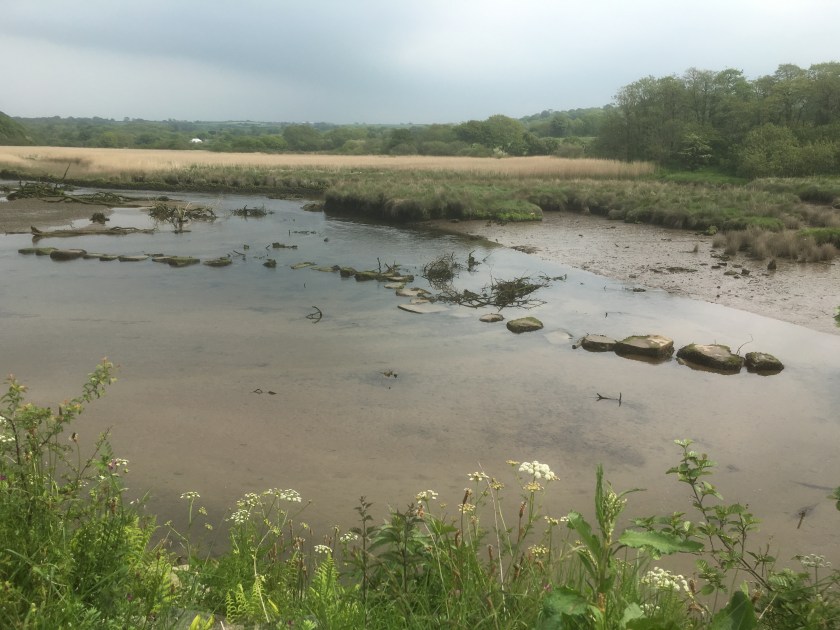
We had a couple more descents to sea level and climbs back up again, including a chance for Sharon to re-live the stepping stones experience.

Careful does it

And then the sight of Newport Sands appeared around a corner.

Newport Sands

A very steep descent followed…

and by now the coats were off, the sun was shining and the sky was a deep blue – typical walking weather for us.  Newport Sands came ever closer.

The path then dropped almost to the beach before frustratingly going back up again, so at this point we decided to do a little bouldering and get ourselves down onto the sands and enjoy the beach.

What a stunning beach

After a coffee and cake stop we headed across the golf course, and followed the river inland to get to the bridge.

With the tide out we were able to see the Pilgrim’s stepping stones, which we had made a pilgrimage of our own to see previously.

Over the “iron” bridge

The walk then continued back along the other side of the river to Parrog.

And to the car-park where we started. A day of contrasts and beautiful weather, and 9.2 miles of new coastal path for us with over 215 storeys of height.  For those keeping score (like me) that makes 494.2 miles completed and 381 miles to go (roughly)

Newport (Parrog) to Fishguard

3rd May 2019

This weekend saw us take on 3 walks, complete another section of the book, pass the 500 mile point and join up some parts of walks we started 3 years ago.

So as usual we started the weekend with a drive – this time just over 2 hours to get to Fishguard, and we parked up right by our caravan site in time to get the bus to Newport (Parrog). We have been here before when we undertook the Dinas Loop and then drove to Parrog in June 2016 to see the stepping stones, but this time we are heading towards Fishguard.

After getting off the bus at Newport, and walking down a side road we reached the yacht club and a familiar starting place – had it really been 3 years since we sat in the cafe garden having an ice cream here?

Our previous trip to the stepping stones had started here
The tide was out
The old lifeboat house

The old lifeboat house was built in the late 19th Century but only in service for 11 years before being replaced.

After a flattish section past some cottages the walk started to climb and hugged the coast line as we went around Aberrhigian Beach and Aberfforrest Bay.

Looking back towards Newport Bay
And Newport Sands
Sharon sets the pace inland towards Aberrhigian Beach
Aberrhigian Beach

At some point around here I lost my drinks bottle, but didn’t realise until about 5 miles later and Sharon didn’t want to go back for it!!

Crossing over Aberfforrest Bay

After a short further walk along the hilltops you arrive at Cwm-Yr- Eglwys, again a part we had visited 3 years ago as part of the Dinas Head loop.

The 12th century St Brynach’s church which got partially washed away in 1859

And then one of my least favourite signs of the whole coastal path….

Noooooooooo!!

It was this sign 3 years ago which made us realise that Sharon had left Cleo’s lead at Pen y Fan on Dinas Head, and gave me the pleasure of doing the walk to the peak for a second time in one day…. but today we have Bonnie’s lead so we are okay, and we quickly navigate the flat path as by now it is coffee time.

Pwll-gwaelod and coffee time

The sun has now come out and the skies are clearing, wish we had brought sun-cream after all!! I am going to let some of the pictures do the talking now on this stunning part of the coast as we rounded Pwll Cwm, then Pwll Gwylog, Aber bach and Aber Grugog.

Stunning views, and now for a dose of reality, time for a selfie….

Say cheesy – and also a rare glimpse of Sharon’s hat before she lost it the next day

The path then had a sign warning of deep holes, but the animals who had created these very deep holes had very thoughtfully done so between a set of posts each time – very clever.

Watch your step
One of the offenders

The walk continued on hill tops past needle rock and towards Fishguard fort.

We have decided that Needle Rock should be called crocodile rock instead:

Or is it just me that can see a crocodile head at the bottom of the picture!

That was a steep descent

What can I tell you about Fishguard Fort – well it was built in the late 18th Century to protect Fishguard after an attack from the Black Prince, a pirate ship demanding a heavy ransom. This was the last attack by pirates on any town in the country but the fort’s heavy cannons saw off the French and instead they landed further down the coast – oh well, that’s someone else’s problem!!

After the fort there was a brief woodland section and then you had to join the road to walk down into Lower Fishguard.

Lower Fishguard

The walk crossed the bridge and then turned right along the estuary before starting a climb. That is where we stopped for today as going on to Goodwick would have taken us away from the car – so here is the sign to pick up from on a future walk.

The end point of today

10.7 miles walked today, of which 9.2 miles counted towards the coastal path. That takes us to 485.0 miles completed and 390.2 miles to go. Time to find the caravan and relax before a longer walk tomorrow.

Moylgrove to St Dogmaels

29th May 2016

Our second walk of the bank holiday weekend was a bit more ambitious and involved a lot more planning. The first plan from Sharon which left us with 2 cars in various places and us in a third place was quickly discarded and a better plan agreed. More ambitious because this walk included the highest point on the Pembrokeshire section of the coastal path and the book described the full walk as “a brute”, thankfully with the kids joining us we decided to do half of it today.

So my car was packed with the picnic and beach equipment and left in St Dogmaels (the end of our walk and the incentive to complete the walk was lunch!!) and we then drove to Moylgrove in Sharon’s car, spotting a mad-hatters tea party themed village on the way. Up front I want to say that I can not do the beauty of this walk justice in the pictures I have capacity for on here, so please go to the Facebook page Walkiescleo afterwards to see all the amazing pictures.

Loaded with water, sun cream and sun hats (as it was going to be a scorcher today) we set off from Ceibwr Bay and the site of Careg Wylan.

IMG_2445

We started with a small drop to cross a bridge in the cove…

IMG_2452

And then the steepest climb of the day was in front of us – this didn’t get us to the top, but most of the day was then about small ups and downs from this base height apart from one bit climb just before the Cemaes head peak.

Most of the walk was grassland with a thin footpath which was baked hard, and we passed a massive group of tourists coming the other way with guides.

We had to stop a few times for drinks breaks and to reapply sun-cream as we reached 2 hours into the walk at around 12 and still had a way to go. Water supplies ran out just before Cemaes Head but Cleo had a plan.

IMG_2479

Then came the big climb to over 500 feet in height, and Cleo decided to have a sit down on the slope for a breather.

A few more shots now of the fabulous views on what, for me, has to be the best day of walking so far for the pleasure of the surroundings – but if we had followed the planned route of the book we would have done 8 miles more before even getting to the start!!

With all the drinking water gone we were starting to dehydrate but as luck would have it we came across a farm campsite called Allt Y Coed which offered bottles of cold water for £1 each, so £5 in the honesty box and we were up and running again, well not running so much as walking!!

The next part of the walk was downhill and along lanes with Poppit sands in front of us.

IMG_2504

And then along the estuary to St Dogmaels which was our end point, and also the end point of the entire Pembrokeshire section of the coastal path – so we have done the first mile at Amroth and the last few miles here, but not the 170 or so miles inbetween!!

And then the reward – a picnic lunch on the beach, and for the adults and Mr Stickman a lie on the sand, but for the kids a run around in the sea.


Strava put the distance at 9.1 miles but more impressive was over 2000 feet of elevation. That makes 153.1 miles walked in total and 716.9 miles to go.

Dinas Island Loop and Parrog

28th May 2016

With the caravan sited in Cardigan Bay, and with 3 of the kids in tow, we decided to pick off a few of the shorter paths during half term which would help us make the days more manageable when we return later in the year.

So on a lovely hot sunny Saturday we drove to Pwll-gwaelog (which is just past Newport – the Pembrokeshire one). There is a small free car park next to the Sailor’s Arms pub and we parked there to make our ascent. Although the walk has some height to it, the whole circle is only 3.5 miles but it will save 2.6 miles from a future long walk as we can cut across the middle.

IMG_2361
Pwll-gwaelog is a part sandy bay with tall hills on both sides

After leaving the lovely cove you are immediately faced by a steep uphill along a narrow road followed by a steep uphill up a path.

Quite quickly you reach a decent height of 300 feet or so and the views are back towards Fishguard harbour, out to sea and at the steep drop below!!

Most of the people were walking the other way, but we decided that clockwise would get the best views as we dropped down into Cwm-Yr-Eglwys  later, so we said our hellos and kept walking, it was quite a busy path.

Then after 1.2 miles we reached Dinas head and the peak of our walk at 441 feet.

We had a sit for a few minutes while we took in the views and had a drink, then set off on the downward section, although initially every downward section was met by more upwards walking, and we past through some woodlands and alongside some cliffs with sea birds.

The descent then got steeper and we could see the estuary by Newport as we came down into Cwm-Yr-Eglwys.

Cwm-Yr-Eglwys is a really cute small village with a tiny beach and dominated by a ruined church and graveyard.

It was at this point that Sharon realised that she no longer had Cleo’s lead, and decided that she had probably left it 1.4 miles back at the very peak of Dinas Head when we stopped for a drink. With not many shops around and the lead being rather essential we decided that we would continue with the circular loop back to the car, have a coffee and cake and then set about retrieving the lead. First we had to pass through the campsite where Sharon gave Cleo a helping hand, and then it was a straight flat 0.9 miles back to the car making 3.5 in total.

IMG_2413

I should then put all the same pictures on again as we walked 1.2 miles back to the peak, collected the lead and then walked 1.2 miles back again to the car…but the strava graphics show it best.

It is worth just mentioning our further adventure on the way back.  Sharon had heard about the Pilgrims stepping stones at Newport and although we pass through Newport on a future leg of the walk she decided we would stop in Parrog and walk a mile to the stones. As the tide was out we could then leap from one to the next right across the river….you get the picture.

So it was a short walk along the river bank to reach the bridge which had replaced the stones as the means of getting across the river. We walked over the bridge and asked some locals where the famous stepping stones were and they looked blankly at us.. and then we saw them (just!!).

IMG_2429

Not quite what Sharon had imaged and it turns out the ones she was picturing in her mind are actually near Brdgend!!

So in terms of the total walk today, all in it was 9.9 miles but only 2.6 miles of it was coastal path (first time around) taking us to 144 miles completes and 726 to go.

Andrew and Sharon

%d bloggers like this: