Carmarthen to Kidwelly

18th June 2016

This walk is certainly one of our more challenging, and longest – but it joins up two completed sections (having already walked from Llansteffan to Carmarthen and from Kidwelly to Llanelli). So we set off at 8.15am to drive to Kidwelly station just in time for the 9.30 train. It was a bit of a surprise to have to put our arm out to stop the train, but thankfully it did stop and we got on and paid the £9.60 fare. The train station at Carmarthen was deliberately the end point of a previous walk so directly we set foot off the train we were at the start of the coastal path – and today was one of those rare days when every step taken was part of the coastal path.

Thankfully within a mile of so, through industrial estates, we hit upon a McDonald’s – albeit the worlds slowest McDonald’s – nearly 20 minutes for breakfast to arrive – we thought about sending Cleo through the drive thru.

IMG_2709

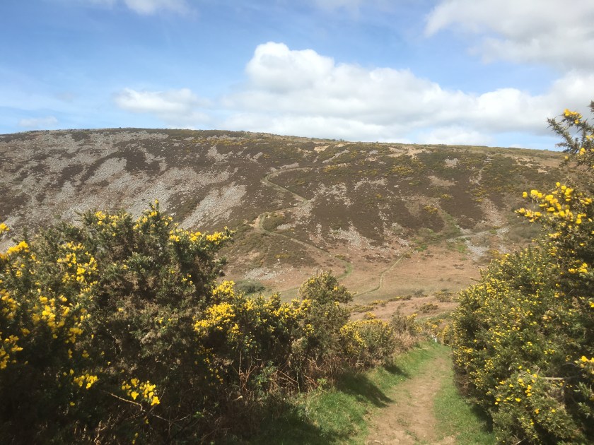
Then we were on our way and the main road soon became a slightly quieter road (but with no pavement) and then, once we had past through Croesyceiliog, we turned right down a country lane. Finally, after 3 miles of walking we got our first glimpse of the coast.

There is a certain irony to the next part of our walk as it was shortly after Sharon said that it was the best signposted path she had seen, and asked me to picture it, that we got lost!!

IMG_2720
One of many posts and signs

We are not sure how, but we missed a turning and ended up following a road and added about a mile to our journey but, after a “sun cream and water” break we made it back on to the coastal path and headed down to the estuary, through Ferryside and to the beach.

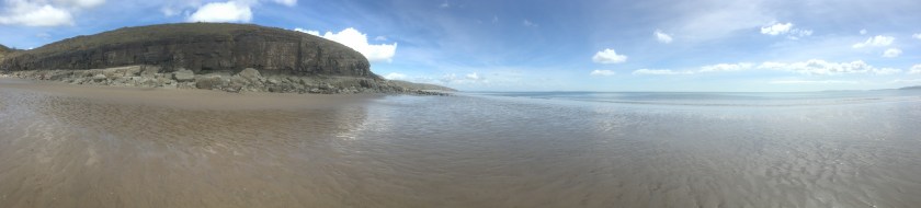
So after setting off at 9.45 it was now 1pm and time for some lunch. We had over 8 miles under our belts already and so deserved the sandy sandwiches (more mayonnaise next time Andrew – noted) as our feet recovered from the morning. The view from the beach was our previous walk and the castle at Llansteffan. Then on we went, deciding to stick to the path and straight away we headed up some steep inclines.

The next part was all woodland paths and fields, again with no coast line. And it has to be one of the least walked parts of the whole coastal paths, judging by how overgrown it was.

We walked through various farms and gardens along the way,  stopping at a farm house where a very pleasant lady thought that Cleo was her dog and tried to call her back inside. Then through a tropical forest with a step descent then a climb back up through a field again and our first paddling pool of the coastal path.

We then headed through Llansaint and the drop down to Kidwelly began, all along an overgrown track.

IMG_2772
A Cleo level view

Annoyingly we could see the train station across the rail bridge but had to walk to the road bridge – we say annoyingly, but when we got to Kidwelly we saw the castle and, more importantly, the Gatehouse tea rooms.

IMG_2781

Well it would be rude not to wouldn’t it, and even Cleo joined in on the act:

The castle itself looked magnificent and a very reasonable price of £12 for a family admission so we shall return there with all the kids to get our money’s worth.

It was then a short walk up the high-street to get back to the car and, just as we arrived the 4.30 train was pulling in. Not the most scenic of days, but plenty of hills and a variety of fields, woodland, coast and town made this a very enjoyable day. And the stats – 15.5 miles walked taking our total to 186.3 miles, and 683.6 miles to go.  Soon be at 200 miles we hope.

Andrew and Sharon

Amroth to Laugharne

24th and 25th April 2016

Sunday now on our weekend away, and the book says that we can do Amroth to Laugharne in a day – coming in at about 13 miles. That is fine – but there are no buses on a Sunday, and our caravan is halfway along the route. So for the Sunday we decide to walk from Pendine to Amroth and back else we would be stranded, and on the Monday complete the walk from Pendine to Laugharne and get a bus back. Job done – but with Sharon still having her sense of coastal rock-climbing adventures in mind and 28.9 miles already in our legs this weekend, this is not going to be easy.

Pendine to Amroth (and back)

So from the campsite we headed towards Pendine Sands and in front of us the hill showed clearly the path we would take.

As we climbed so the beach got smaller and smaller, and our breaths longer and longer…

The view from the top of the first hill (Gilman point) was magnificent

both the views out over the point, and ahead of us Morfa Bychan, a small cove of a beach. But then we saw where the path was leading us – right down to the beach and then back up the other side was another hill which looked even higher than the one we had just climbed up.

IMG_2102

I left this picture full size so that you can see the path cutting up the hillside, around 370 feet up for that peak alone. And this time you stay up high for a bit longer, with some drops but not back to sea level…

Unless of course you are Sharon. Marros beach stretched out below us, with no-one on it. We meet some walkers coming the other way and they asked if we knew a way down on to it because they reckoned that if they could get down then they could walk along the coast at low tide past Telpyn point (Left picture above) and straight into Amroth avoiding the last hill. We didn’t, but helpfully we pretended to offer up a path behind us which might go so far. In return they told us that ahead we could drop down and get on the beach and might be able to time it right to get to Amroth – just under an hour till low tide and Sharon not only wanted to walk the beach all the way to Amroth but also then stop for food and find the time to turn around and get back along the beach as well.

We went for it, and with a bit of rock climbing (but nothing like yesterday) we got around the point and onto Telpyn beach and Amroth.

IMG_2146

It must be said, Amroth is beautiful….even though the official end point of this walk (and the start of the Pembrokeshire coastal path) was right at the start of the beach, we decided to walk the length of Amroth (an extra mile or so) and it was well worth it. We could easily see the seaside house being here – definitely high on the list.

But then we had to turn around and walk back – Sharon was determined to get past the first point on the beach to avoid a hill but I wanted to note the start point of the Pembrokeshire coastal path….

Then we made it around the point before we stopped for a sandwich, and I tested Strava’s ability with a run along the beach (was looking better before we then walked right through it!!)


At this point we had a choice – someone showed us where we could get off this beach further down and back over the 2 hills to Pendine – or we could go for it and try to get round another point with the rapidly encroaching tide. Guess which Sharon chose, despite the warnings of some fishermen that it would be tricky…. so rock climbing we went again, carrying Cleo all the way, and it was a good 15 minutes of climbing..

But we made it, leaving just one hill to climb and then we were back in Pendine – today was 13.7 miles and a massive 1930 feet of ascent, despite the beach cheats!! But only 6.8 miles of coastal path. Meaning 130.7 miles completed and 739.3 miles to go.

Pendine to Laugharne

And so a leisurely morning for our last walk of the weekend, and it needed to be with blistered feet and 42.7 miles already walked this weekend.

So we set out from Pendine and the coastal path pretty much followed the road right up to Broadway.

The path then suddenly went up some steep steps and into Dylan Thomas land – starting with a sign about the famous Llareggub uprising (in case you need it explaining – read it backwards)

IMG_2173

There are benches with famous lines from his poems all the way along, and then the estuary hits you with splendid views of Laugharne castle

A few landmarks – Dylan’s original house, the shed above the boathouse where he wrote, and a pink house (nothing special about the pink house except that we saw it from a distance on Saturday and since then every time we went past a red house Sharon asked if it was the pink house, yet she missed the actual one in Laugharne, so I have to include a picture of it for her!!)

Add the end point was the bus stop where we got to on Saturday

IMG_2198

As we sat in a lovely cafe in the town centre eating a fab breakfast, and then some fab cake as well (two meals in one!!), we realised we had walked 7.2 miles today, making 49.7 for the weekend in total and all of it was coastal path, making 137.9 miles in total and only (ha ha only) 732.1 miles to go. Roll on the next weekend,

Andrew and Sharon

Llansteffan to Laugharne

23rd April 2016

It is unusual for us to walk on back to back days, but with the caravan booked for the whole weekend  we planned 4 days of walking and this is the second and by far the hardest. The book says it is 15 miles in total, and also very hilly (that will please Darren), and it is quite a trek just to start out.

To be honest – we only planned to go as far as St Clears today (about 10 miles) – hence we parked the car there in the morning (7.30!!) and got the dog friendly bus into Carmarthen, had breakfast at Wetherspoons and waited for the dog unfriendly bus (back in the rucksack again Cleo) to Llansteffan. Off at the same bus stop as yesterday but this time we went left not right and headed for the beach and the castle.

For once we were prepared and even knew that low tide was just before 2, so as we walked along the beach we could see the tide receding. The official coastal path then heads up the hill and past the castle – but Sharon has this wonderful theory that we should try to always be as close to the coast as possible, and that if the path sometimes goes in land a bit, then we should seek alternative routes.  Today was one such day. The beach was so appealing to Sharon that she decided to see if we could walk on it for as long as possible and miss a few of the hilly bits.

Our feet were sinking quite deep in the sand, at some points above the tops of the walking boots, but the sun was shining and we had the whole beach almost to ourselves.  We reached a rocky part and after climbing over a few rocks we saw a guy and his dog sitting on the rock waiting for the sea to retreat far enough for him to get the fish out of his net.

We asked him if we could carry on along the rocks and get to the next beach and a way up to the coastal path. He laughed a bit and said it would be possible in about an hour once the tide went out enough and that on the next beach there we would see a blue rope which would lead to our exit. So off we set (with his cries of “good luck” still in our ears), more mountaineering than walking and definitely slower than if we had walked up the hill, but it was fun.

At times the drops between rocks were 10 feet or more and we eased ourselves down the slippery rocks until finally we made it to another beach. We walked along looking for the blue rope but to no avail, and at one point almost got completely stuck in the sand as we sank up to our sock tops in it.

IMG_2064
A bit too sinky!!!

We passed a man farming muscles, and then continued around a corner where we could then see no way past – it was all estuary or marshland and after a bit of exploring we turned around and walked back along the beach till we found another fisherman who showed us where the blue rope was – to be fair, we had to go in through a stream and woodland before finding it and then use the rope to climb up a very steep hill.

Sharon led the way up the hill and at the top we found the coastal path and the more traditional view.

We were quite behind now so decided to stick to the coastal path for the rest of the journey, even though it had to go inland at times, and it was a mixture of lanes and fields.

We found a lovely quiet spot for lunch and a snooze in the sun.

IMG_2074
Lunch time and snooze time

At one point we went past a farm and the sign said to go through the farmer’s field, so we did and then got completely lost wandering from field to field, stepping boot deep in cow slurry this time (Andrew!!) and after an hour we gave in and went back to the farmhouse to ask for help. Turns out the route was through a field of cows (who were very interested in Cleo) and the farmer had taken down one of the signs to avoid people using it we think. We found an alternative route through a neighbouring field and continued up and over the hills.

Finally we approached St Clears – well as close as the coastal path went to St Clears by the boatyard.

The coastal path then headed off to the left to Laugharne, or the car was right to St Clears – but even that was 1.5 miles away so we decided (foolishly) that we might as well finish off to Laugharne and then get a bus back to get the car.

I was running out of phone battery life at this point and we needed to rush for the bus so pictures are limited, but it was much the same as the other side of the estuary and we spent a lot of time on or near the road. Finally we made it to the bus stop in Laugharne just in time for the last bus of the day. Laugharne itself, pretty as it looked, will have to wait until we have more time another day.

So the stats – we were supposed to do 10 miles of a 15 mile coastal path walk – but with detours ended up doing 17.4 miles of walking and all 15 miles of the section. Our total ascent was 1501 feet which was pretty impressive. That takes us to 123.9 miles of the coastal path completed, and 746.1 to go. And another walk to come tomorrow!!!

Andrew and Sharon


LLansteffan to Carmarthen

22nd April 2016

With a weekend away in a caravan in Pendine booked up we decided to tackle a few legs of the coastal path over the weekend. Friday was the only poor  weather forecast for the whole weekend but with an early enough start we might just be able to beat the rain. The only problem was that having parked in Carmarthen, the bus to get us to Llansteffan to start the walk wasn’t until 11.40 – time for Greggs!!

We were stood in the bus station with Cleo, when a woman approached us and said “they don’t let dogs on the Llansteffan bus anymore, after one did a poo”. Sharon was worried that if she did the same then all middle-aged women would be banned from the buses as well – but our problem was that we needed that bus – and we needed Cleo to be on it.  So we walked around the corner, put Cleo into the rucksack and subtly got on the bus – thinking we got away with it.

IMG_1989
Cleo poking out of the rucksack

I say “thinking we got away with it” as when we got off the bus in Llansteffan the driver said “hope the little fellow enjoys the day”, and I don’t think he was talking about Andrew!!

After a false start in the wrong direction we headed up a very long and steep hill:

And that was most of the walk really – across a few fields, along a few roads (often with the coastal path popping in and out from behind a hedge) and (according to Sharon) mainly uphill, although Strava was to disagree).

We then found ourselves in a lovely BlueBell forest, which proved a good spot for some lunch on a bridge by a stream.

Re-fueled and re-energised Sharon had a game of hide and seek while Cleo took to some showjumping.  Then we climbed some stairs and through a gate to cross the main road:

IMG_2013

Then after some more woodland and some more ups and downs we met some fellow coastal path walkers – although I suspect they are slightly more dedicated as they had been walking for a week and had got from Swansea. We shared a few tales of misadventures and then off we went to have some more!!

An arts centre proved good for a pit stop before we headed along a floodplain, passed behind the B and Q that you always see when heading to West Wales and pass some fish sculptures. The pace picked up as the rain began to fall.

The bus station was on our left but we wanted to end at the train station so that we could pick up from there another day. So we crossed on the Pont King Morgan footbridge and found the station.

IMG_2026
The finish line

So today’s walk was 11.5 miles in total in 3 hours 26,  of this 9.5 miles was of coastal path making 108.9 miles walked and 761.1 to go!!

Andrew and Sharon

Kidwelly to Llanelli


Making the most of our caravan site location we today drove to Kidwelly and left the car at the railway station, with the plan to walk to Llanelli (13 miles according to the coastal path book) and then for Andrew to get the train back to get the car while Sharon and the kids played in the park by the discovery centre (the finishing point of the previous leg from Pen-Clawdd to Llanelli.

So here is the Kidwelly train station sign with the coastal path sign on a lamppost, and the kids and their bikes waiting for a train to pass. Cleo was ready to go, and after a short walk down a lane we got our first glimpse of the coast today.


We walked along a canal and then briefly on the main roads until we reached the wetlands, and here the winds really battered us (we had chosen to walk this way to have the wind aiding us most of the way, but here it was very much against us with 40mph gusts). Overhead there were two fighter jets having a mock battle.

Lunchbreak time and a wall sheltered us from the wind. The salt marshes here were green but it was a very low tide and when Andrew passed here much later in the day on the train the area was flooded except for the raised path.

So after marshland the coastal path then gave us forest, with a couple of miles of woodland walks. And here our book suggested we turn left and continue with 4 more miles of woodland to the Pembrey country part, but we followed the signs (maybe they are newer than the book) and went straight on until we hit the beach. Having got past the initial sand in the eyes moment we got down to the solid sand with the tide miles out.

What an amazing beach, and completely empty, we have never had a whole beach to ourselves before and we did some beach combing for shells.

The wind was at our backs now and blowing hard, with sand whistling past us, so we didn’t often look back but when we did the sky was very dark.

Trying a panoramic picture on the blog for then first time, the left being sunny, the right being rainy.

IMG_1837


The sand made some wonderful swirling shapes, the sand is flat, all the shapes are blowing sand.

Just time for Sharon and Cleo to pose before we rushed on, with the storm clouds out over the sea, although somehow the rain managed to miss us.

Then we saw a way off the beach into Pembrey country park (where the caravan was going to be before the site was flooded) and headed in land, where the coastal path went right past the dry ski slope and we stopped so that the kids could have a quick toboggan run.

And then after a climb over the toboggan hill we left the country park and headed towards Burry port on the cycle path and coastal path all in one. Looking across the estuary we could see part of where we walked on Tuesday and part of where we will go in the future.

By now the tide was coming in and the wind was making the waves quite large. Time was also ticking on and we knew there were trains at 5, 5.30, 6, 6.30 and then nothing till 8, so with a brief look at Burry port we continued the walk.

We were looking for the amazing circular shell shaped grass lands, and almost missed them till we looked behind us as we reached the barge.


Absolutely amazing, and we nearly missed it, although seeing it meant we did miss the left hand turn to go over the railway line and added an extra mile or so doubling back and up a steep bank. Then for our favourite bit of the day, we wanted a picture of us all on the grass steps, so Andrew asked a rather old passerby to take our picture. After his first attempt Andrew looked and he had turned the camera around to take a selfie, the second attempt was no better, and on the third attempt he managed to not only turn the camera round but also to take an 18 shot burst of himself…. We gave up!!! Here is his best picture.

IMG_1887


And here is the empty step which we took after he had left so as not to hurt his feelings.

IMG_1907


The pace quickened,and again we missed a poorly signposted turn which would have kept us closer to the railway track. But the bike path ran parallel and didn’t cost us much time. A little bit of history for you now and to tell you about this plague to celebrate the landing point of Amelia Earhart, the first woman to fly the Atlantic Ocean single handed in 1928.

IMG_1908


And then we suffered from a sign being turned the wrong way and ended up walking to the discovery centre along a road and not the coast, but we were not turning back now. So while the official book says the walk is 13 miles we actually walked 15.8 miles, and then Andrew had to sprint half a mile to the train station to get the train back to Kidwelly (free as no ticket collector), and back in the car to collect the family.

IMG_1912

Without doubt the longest we have walked on the coastal path in a single day (the blisters prove this), but the best day so far in terms of the magnificent scenery and the variety of the walk from marshes to forest to beach to estuary, absolutely fabulous. For the official tally… 13 miles completed on this leg (although the book might want to add a mile or two for being able to go along the beach), so that is 92.7 miles completed and 777.3 miles to go!!!!


Pen-Clawdd to Llanelli

After walking almost 50 miles in Edinburgh last weekend (48.6 miles to be precise and not a step of it counting towards the coastal path alas), we are back on the trail this weekend, with kids in tow.

As luck would have it we have a few days on Gowerton caravan site with the van, and the coastal path runs right by the front door…. how convenient, and our first walk on the Carmarthenshire and the Gower section of the coastal path.

We are sited about a third of the way along the Pen-Clawdd to Llanelli leg of the path so for Saturday we decided to turn left and pick up the first third. That bit was sensible, however, letting the kids take bikes on a non-bike path section was slightly less sensible.

So we turned left out of the campsite and walked to the main road, where across the other side of the road the coastal path ran down an alleyway and into a muddy wood.


There were a few stiles and gates to navigate with the kids bikes, as well as 4 inch deep mud in places, and a few bemused looking sheep, not used to seeing people on bikes. After briefly touching the road at one point, the coastal path then joined the road for the rest of the journey into Pen-Clawdd.


The rest of the way followed either the bike path or pavements and ran along beside the Burry estuary.

Continue reading “Pen-Clawdd to Llanelli”

%d bloggers like this: