Criccieth to Penrhyndeudraeth

4th October 2019

Our last walking weekend of the year and a final chance to get some serious mileage in before winter. This weekend we will be on the Lyn Peninsula section of the coastal path as well as the Meirionnydd Section as our campsite for this weekend is right on the edge between both sections of path.

So after a long drive up we parked up at Morfa Bychan just as the rain was stopping and decided to try to fit a 10 miler in before dark. Because of the timing of the trains we had to walk from Morfa Bychan to Penrhyndeudraeth, and then get a train right the way across to Criccieth, and then finish the walk from Criccieth to Morfa Bychan. And the train was at 4.40pm so we had to walk at a decent pace.

Our campsite was right on the beach and as we climbed over the dunes we got our first glimpse of a very nice beach

We had about a mile to walk until we needed to go up the steps at the end to get around the cove at Sampson’s Bay.

Up we go at Ynys Cyngar

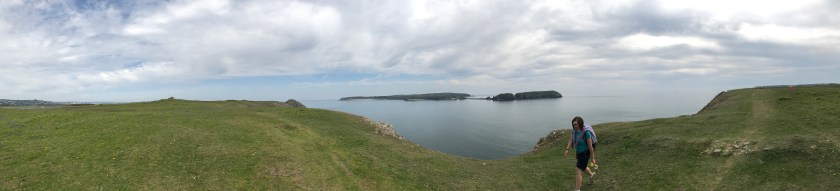
And here is the BayWe then walked through some woodlands, and through Pen y Banc nature reserve to get to Borth-y-Gest.

Some views of walks for later in the weekend

Borth-y-Gest used to be an important harbour until Porthmadog was built, now it is a sleepy colourful harbour.

Borth-y-Gest
Complete with car park and cafe

Rounding this harbour bought us to the much larger Porthmadog Harbour with tall masts and a maritime museum.

After joining the main road to cross the river the guidebook told us to cross over and follow the bike-path along the salt marsh – the views were nice, but we later found out we could have walked up high on ‘The Cob’ which would have been even nicer looking out to see and with the heritage trains.

Traeth Mawr salt marsh

At the end of the path we had to walk under an arch and cross the road and railway line.

Underneath the arches

Then up a steep and muddy path – but the views at the end of Porthmadog and beyond were well worth it.

We then crossed some fields and hit the edge of Portmerion – but as you have to pay to enter we skirted around it. At this point the signage became rather vague and we also found a fellow lost coastal path walker so we teamed up and walked down the Portmerion access road until the coastal path crossed over in front of us, we could rejoin it and we said our goodbyes to the slower walker as we had a train to catch.

The next section was all along the main road so we could get a good pace up and we arrived at the railway station with 2 minutes to spare.

The coastal path sign by the station to pick up from on a future walk
The station itself

A nice 15 minute train ride enabled us to catch up on cold coffee from the flasks and a snack, and then we arrived in Criccieth and walked the half a mile back to the coastal path.

The sign to start this end of the walk

In Criccieth we first had to walk up and down the hill to pass the castle.

The back of the castle
It is more impressive from the front

And then we walked along the seafront at Criccieth.

We tried to stay on the beach the whole way to Morpha but the tide was in just too far at Graig Ddu and we had to climb up the hill.

Looking back to the castle
Graig Ddu
Some of the hill we had to climb

But looking down we could see a way to clamber down the rocks and get back onto the beach rather than climb even higher, so with the light starting to fade we made our way gingerly down the rock-face, mostly backwards!!

But then down we dropped as twilight started to fall

It was then about 1 mile along the beach to get us back to the campsite and all checked in by 6.15pm. A good afternoon of walking with plenty of views and sights of interest……10.3 miles walked today, making 516.7 miles completed and 358.5 miles to go. Now off to re-plan the rest of the weekend as tomorrow the rains come in early in the afternoon and we wanted to walk 15 miles before they do!!

Newport (Parrog) to Fishguard

3rd May 2019

This weekend saw us take on 3 walks, complete another section of the book, pass the 500 mile point and join up some parts of walks we started 3 years ago.

So as usual we started the weekend with a drive – this time just over 2 hours to get to Fishguard, and we parked up right by our caravan site in time to get the bus to Newport (Parrog). We have been here before when we undertook the Dinas Loop and then drove to Parrog in June 2016 to see the stepping stones, but this time we are heading towards Fishguard.

After getting off the bus at Newport, and walking down a side road we reached the yacht club and a familiar starting place – had it really been 3 years since we sat in the cafe garden having an ice cream here?

Our previous trip to the stepping stones had started here
The tide was out
The old lifeboat house

The old lifeboat house was built in the late 19th Century but only in service for 11 years before being replaced.

After a flattish section past some cottages the walk started to climb and hugged the coast line as we went around Aberrhigian Beach and Aberfforrest Bay.

Looking back towards Newport Bay
And Newport Sands
Sharon sets the pace inland towards Aberrhigian Beach
Aberrhigian Beach

At some point around here I lost my drinks bottle, but didn’t realise until about 5 miles later and Sharon didn’t want to go back for it!!

Crossing over Aberfforrest Bay

After a short further walk along the hilltops you arrive at Cwm-Yr- Eglwys, again a part we had visited 3 years ago as part of the Dinas Head loop.

The 12th century St Brynach’s church which got partially washed away in 1859

And then one of my least favourite signs of the whole coastal path….

Noooooooooo!!

It was this sign 3 years ago which made us realise that Sharon had left Cleo’s lead at Pen y Fan on Dinas Head, and gave me the pleasure of doing the walk to the peak for a second time in one day…. but today we have Bonnie’s lead so we are okay, and we quickly navigate the flat path as by now it is coffee time.

Pwll-gwaelod and coffee time

The sun has now come out and the skies are clearing, wish we had brought sun-cream after all!! I am going to let some of the pictures do the talking now on this stunning part of the coast as we rounded Pwll Cwm, then Pwll Gwylog, Aber bach and Aber Grugog.

Stunning views, and now for a dose of reality, time for a selfie….

Say cheesy – and also a rare glimpse of Sharon’s hat before she lost it the next day

The path then had a sign warning of deep holes, but the animals who had created these very deep holes had very thoughtfully done so between a set of posts each time – very clever.

Watch your step
One of the offenders

The walk continued on hill tops past needle rock and towards Fishguard fort.

We have decided that Needle Rock should be called crocodile rock instead:

Or is it just me that can see a crocodile head at the bottom of the picture!

That was a steep descent

What can I tell you about Fishguard Fort – well it was built in the late 18th Century to protect Fishguard after an attack from the Black Prince, a pirate ship demanding a heavy ransom. This was the last attack by pirates on any town in the country but the fort’s heavy cannons saw off the French and instead they landed further down the coast – oh well, that’s someone else’s problem!!

After the fort there was a brief woodland section and then you had to join the road to walk down into Lower Fishguard.

Lower Fishguard

The walk crossed the bridge and then turned right along the estuary before starting a climb. That is where we stopped for today as going on to Goodwick would have taken us away from the car – so here is the sign to pick up from on a future walk.

The end point of today

10.7 miles walked today, of which 9.2 miles counted towards the coastal path. That takes us to 485.0 miles completed and 390.2 miles to go. Time to find the caravan and relax before a longer walk tomorrow.

Amroth to Freshwater East in a weekend

19th and 20th May 2018

This is a double-header update to cover the walks both sides of Tenby.

On the Saturday we set off early from home and drove to Amroth, parking right on the seafront with free parking. We were also only 10 metres from the bus stop, so today will count as the day with least extra “non-coastal path” walking.

After a delicious “Pirate” breakfast we got the bus to Tenby, and that was quite a scary ride down some narrow lanes.

IMG_0002
The bus heading along Amroth front towards us

And off we set from Tenby for the walk – the coastal path isn’t signposted at all through Tenby so you just make your way through the town and down to the harbour and North beach.

The coastal path then rises sharply firstly along a road and then through some fields.

The path then stays quite high for a while with views of the coast through hedges and trees before dropping down to sea-level in a little cove just before Sandersfoot. We stopped for a coffee and Sharon decided to have a paddle in the very cold water.


IMG_0025

The tide was in too far to walk around the coast on the beach, so we climbed back up to continue the walk to Saundersfoot.

IMG_0027

And after a surprisingly short stop for shopping we headed out of Saundersfoot in the glorious sunshine and through a tunnel, yes a tunnel, to get to Coppet Hall Point.

IMG_0028
One of the two tunnels

After a suntan lotion stop we went through a second tunnel and along a very well walked part of the path to Wiseman’s bridge. By now the tide was well on the way out, and we were able to walk from Wiseman’s bridge all the way to Amroth on the beach over rocks.

And there was the car – so a lovely stroll of 7.6 miles and we had joined up to our previous Laugharne to Amroth walk.

After a great evening in St Florence and a good pub meal we set off the next morning for day 2 – parking in Tenby and getting the train out to Lamphey – which is about as close to the coastal path as we could get to start today.

IMG_0037

By “close” I mean about 2.5 miles of walking to get to the coastal path, most of it along a road, so not the most exciting of starts, but at least we had some cloud cover today to stop it being so warm. And after a steep descent we made it to the start point by Freshwater East beach.

The coastal path heads behind the beach through dunes, and then sharply up a steep climb to get to West Moor Cliff; the views here are mainly behind us back towards Freshwater East.

IMG_0046

Ahead of us though from this height Sharon kindly pointed out our future path around Swanlake Bay, and it was a big drop and rise again…..

The climb up East Moor Cliff was a big one, and to then turn the corner and see another drop down, this time into Manorbier Bay was a little disheartening, but the views along here were magnificent because of the height.

We stopped for lunch at Manorbier Bay, but didn’t have time to see the castle. Then off we set again up Priest’s nose this time, and if you look closely you can see fishermen sitting in very precarious positions on the rocks below us.

We then climbed up and around Presipe Bay, where thankfully we didn’t have to drop down to the beach for once – although Alice and her family had done.

IMG_0066

The path then has to turn inland to avoid Manorbier firing range, and there were some neat dog openings on the stiles. It was also a chance for the pace to pick up on some concrete paths.

IMG_0069

Then suddenly Caldey Island came into view, and from an angle that we had never seen before.

IMG_0070
Caldey Island

IMG_0090

Then once more we dropped a fair distance towards Skrinkle Haven, but this time the way back up was steps, and lots of them. Andrew decided to tackle them in one, and then needed a 5 minute sit down to regain his breath.

Then it was quite a surprise to come out besides some caravans on the Haven Lydstep site, and we got a bit lost navigating our way around the caravans, but Sharon got us back on track, even if it was a very much unused track with lots of stinging nettles.

IMG_0074
A prime position for a caravan
IMG_0075
Lydstep bay
IMG_0077
Overgrown paths
IMG_0078
Sharon steams ahead – must need food!!

After Lydstep the path heads up again to Penally, and with the red flag down we were able to walk across the shooting range, and past the trenches used to train soldiers in WW1.

We then arrived at Giltar Point, but were not feeling brave enough to climb out on it – hard to believe that this beautiful spot is so close to Tenby South Beach, and gives such good views of Caldey Island.

Then we headed through a beautiful small wood and arrived at South Beach.

And we were back in Tenby – so a lot longer day than yesterday – around 6 hours of walking, a total of 15 miles, and over 210 storeys of height. But for the coastal path it was 11.7 miles completed.

So with 19.3 miles completed this weekend our grand total is now above the 400 miles completed mark at 403.7 miles, and 470.5 miles to go. 3 walks away from being halfway!!

Aberystwyth to Llanrhystud

26th March 2018

The final day of the weekend, and we decided to go for it- a full day of 11 miles before we headed home, mainly so that we leave a single walk north from our New Quay base when we return in October.

So we packed up and left Borth at 8am. We parked the car at Llanrhystud and got a bus back to Aberystwyth. After a breakfast in Greggs we headed back to the pier. Just along the sea front was Aberystwyth castle so we stopped for a nose.

Aberystwyth castle

The view from the castle

The coastal path then takes an inland turn to cross Avon Rheidol before heading past the harbour and along the sea wall.

Aberystwyth harbour

Then our first decision of the day, the coastal path stays on cliff tops all day, but our guidebook says that at low tide you can walk along the beach for that true coastal experience. The tide was certainly low(ish) but on its way in, so we decided to start on the beach and then head up once we got cut off.

By going on the beach we avoid this rather large hill

Now this sounds a great plan, but there were two problems with it….firstly the beach was mainly covered in large rocks and slate dropped from the cliff above so was very slow to navigate. Secondly after about 3 miles of this it was becoming clear that the coastal path was not dropping down to the beach any time soon.

Slate outcrops
Fallen from above
Some amazing rock formations
Sharon and Bonnie navigate the rocks


And then the dilemma; we saw a set of steps through a campsite to get us off the beach and up onto the cliffs, or we could risk there being another exit on the beach further down before the tide comes in. We chickened out and left the beach for a steep climb, and further on we were fully justified as the beach was completely cut off.

Exit point, and the sign was a bit late to warn us!

The cliff tops were the usual mix of fields of sheep and steep climbs.

Another steep climb
Sheepy fields
A very picturesque point
So far we could have made it on the beach

The path was blocked by a fallen bush but we climbed that and continued with the clouds heading in. The buzzards started circling overhead!!

Clear the way please Sharon
One of many buzzards

At Penderi cliffs there was a nature reserve but it looked rather dangerous to try to get to judging by the sign.

Head first as well

The path then hugged the side of a steep cliff and was dangerous in places but the sheep seemed to cope.

On the side of a steep cliff
Hold on Sharon
We made the right choice, there is no way we would be walking along the beach there

Finally the path dropped down to a campsite and then along a road and before we knew it we were back by the car.

Caravan park in the distance
Caravan park close up
The end of the walk and the end of the weekend

For those who like statistics, and who doesn’t…..today was 11.3 miles in 4 1/2 hours, and 155 storeys. So this weekend was 46.1 miles in total. Our total distance walked is now 384.8 miles and 489.9 miles to go. Another 53 miles and we will be half way!!

Mumbles to Oxwich Bay

24th February 2018

Our first coastal path walk of 2018, and it’s going to be long one. We started off with a drive to Swansea where we left the car strategically close to a bus stop for later. We then biked the 5 miles down to Mumbles pier and a nice breakfast.

Ready to bike with Bonnie in her basket
Our breakfast view
In a dog friendly restaurant, so Bonnie was very excited

So at 10.25 we set off from the restaurant and headed up some steps to Bracelet Bay and Mumbles lighthouse, before passing Rams Tor and Limeslade.

Up up and away
Rams Tor

There was then a nice new concrete path to take us towards Langland Bay, but not before a rather steep climb up steps.

More steps – a theme of today
A few of the outcrops we will pass today
Langland Bay

And on we went after stopping for a not particularly nice cup of coffee at the Surfside restaurant. 2 miles later we arrived at Caswell Bay, at which point we had to take to the road as the tide was in.

After some more climbing we reached Pwildu bay, with a stream running to the beach and a bridge to cross over the river.

Climbing up through the woods from Pwildu Bay we met a fellow walker – who was walking from Mumbles to Southgate for the 2nd day running (his phone had told him to walk 208 miles this month apparently, and he listened to it!!).  We chatted and walked for a while but we were clearly slowing him down so we said our farewells and he headed off into the distance……

Our fellow walker heading off into the distance

We then headed towards Three Cliffs Bay and a stop for lunch at the halfway spot.

We then dropped down a steep sandy path (glad we didn’t have to walk up it) to a flood plain and stepping stones.  Now anyone who has been following our adventures will know that Andrew has had issues in the past with stepping stones – but not today – all the practice paid off and Andrew cleared them without stopping.

Sharon lagging behind

After walking past Great Tor on the cliffs we knew we could drop down to the beach to complete the walk to Oxwich Bay.

Great Tor

And that was our 12 mile walk, done by 2.45pm.

The end of the walk, joining up with the previous walk

But then we had to wait for the bus, so we popped into the hotel for a nice afternoon pot of tea, and very reasonably priced as well.

Then up the hill for a mile to the bus-stop.

And we got the 118 back to Swansea and the car, and then off to get the bikes.  12 miles completed taking us to 336.7 miles completed and 535.0 miles to go.


Briton Ferry to Aberavon including optional loop

24th September 2017

The purpose of this walk was actually to join up a very short section between Briton Ferry and Aberavon Sands, left from 2 previous walks. But in order to make a day of it we decided to make it a circular walk taking in the red route mountainous section along Baglan as well. So we parked at St Mary’s church in Port Talbot and walked under the M4.

Red route signs

Very quickly the route began a steep climb up grass covered steps, and it just seemed to go up and up and up.

Up the road
And up the steps
Looking back from half way up
Almost at the top

At the top (over 200 floors high according to the fitbit) and the route goes along the ridge besides Mynydd Dinas forest, and gives some superb views over Aberavon and on to Swansea.

The white square factory in the exact centre of this picture is where we will be later on

Then the walk suddenly goes along a road, past a farm and you find yourself in a modern housing estate complete with school – this is Baglan. You then walk along the edge of Briton Ferry forest before dropping down sharply at the McDonalds on the Briton Ferry roundabout – which was perfect – not just to have a wee and a coffee, but also because that is where we ended up on a previous walk.

Another forest
We have been to this sign before, but this time we go left not right

You then head under the M4 and along Afon Nedd, past the Brunel tower

The underneath of the M4
The Brunel Tower

Bonnie was enjoying the river walk as we headed towards her favourite – the beach…..

Bonnie takes the lead
Baglan Burrows
Almost at the coast

Time for one final look behind us at the hill we have just climbed

And we hit the beach, to join up with the previous walk from Margam to Aberavon Sands stopping for a nice panini in the seaside cafe before running for the car in the rain.

A total of 9.7 miles walked, but only 3.7 of them are new coastal path, taking our total to 313.9 miles walked and 555.8 miles to go.

Andrew and Sharon

Colwyn Bay to Llandudno

5th May 2017

Now we are back up and walking we decided to have our first long weekend of the year, where we travel further afield and try to complete a number of legs back to back. So this time we went back to North Wales to continue where we left off at Colwyn Bay and needed to walk West rather than East.

So after a drive of over 4 hours we parked on Colwyn Bay promenade by the old pier. Sharon had the bright idea of taking bikes today to get through the ‘long flat parts’ of the walk. This walk finishes off the Llandudno to Rhyl section we started last October and starts the Llandudno to Conwy section. So at 2pm we headed along the promenade briefly before soon being forced on a detour inland while redevelopment work was taking place.

Our starting point and the detour

We quickly returned to the coast and what a lovely afternoon it was.

Look at that sky
Showing the way

This weekend also gives us three British records…the first is the smallest church in the UK at Rhos-on-sea….or is it? St Trillos seats 6 and would be perfect for a small wedding!!

The smallest church in Britain?
A possible wedding venue for next year?

Then on we went past a golf course and a housing estate towards Little Orme. We had thought we could go around it, and laughed as we passed a steep uphill path.

Our first challenge…Little Orme
Not so little

But after getting to the coast we realised there was no way around Little Orme and the coastal path actually went over it!

The way up!!

Has anyone ever been crazy enough to take a bike up Little Orme? They have now!!

Go Sharon
The view is worth the climb

The views were magnificent though and what goes up must come down, so we headed down the tracks…until I got worried that I couldn’t hear Sharon’s brakes squeaking so I stopped and ran back. In my defence I did check Sharon was breathing before I took the picture …she was ok but did get some big bruises… I asked what had happened and Sharon replied “I fell off!”

Ouch

Bonnie was not involved in the crash and was just having a Lassie moment. Once we were up and running again it was a fast downhill all the way into Llandudno along the promenade.

Llandudno looking back to little Orme
Mad as a hatter…part of the Alice trail
Little Orme

We parked up the bikes and took a walk on our second record breaker… Wales’ longest pier and the fifth longest in the U.K. A nice coffee and cake later and we were ready to cycle around Great Orme, but even then we had a long steady climb which we ended up walking most of.

They even put out the welcome for us
Big Orme
What a view
Bonnie still full of energy

As we rounded the head and could see views to the south we readied ourselves for the big downhill.

Llanfairfechan in the distance
Ready for the downhill again, stay on this time

We hit 29mph heading down which made dragging the bikes around all day worthwhile. The Cheshire Cat marked the end point of today’s walk.

Smile!!
A pretty map and 990 feet of ascent

Andrew took Bonnie on the bus to collect the car, and she slept all the way.

Time to sleep on the bus

The stats for the day in terms of the coastal path are…6 miles of the Rhyl to Llandudno leg completed and 6.2 miles of Llandudno to Conwy making 12.2 miles in total. The overall total is now 258.1 miles completed and 611.6 miles to go. Time to rest up for a long walk tomorrow.

Carmarthen to Kidwelly

18th June 2016

This walk is certainly one of our more challenging, and longest – but it joins up two completed sections (having already walked from Llansteffan to Carmarthen and from Kidwelly to Llanelli). So we set off at 8.15am to drive to Kidwelly station just in time for the 9.30 train. It was a bit of a surprise to have to put our arm out to stop the train, but thankfully it did stop and we got on and paid the £9.60 fare. The train station at Carmarthen was deliberately the end point of a previous walk so directly we set foot off the train we were at the start of the coastal path – and today was one of those rare days when every step taken was part of the coastal path.

Thankfully within a mile of so, through industrial estates, we hit upon a McDonald’s – albeit the worlds slowest McDonald’s – nearly 20 minutes for breakfast to arrive – we thought about sending Cleo through the drive thru.

IMG_2709

Then we were on our way and the main road soon became a slightly quieter road (but with no pavement) and then, once we had past through Croesyceiliog, we turned right down a country lane. Finally, after 3 miles of walking we got our first glimpse of the coast.

There is a certain irony to the next part of our walk as it was shortly after Sharon said that it was the best signposted path she had seen, and asked me to picture it, that we got lost!!

IMG_2720
One of many posts and signs

We are not sure how, but we missed a turning and ended up following a road and added about a mile to our journey but, after a “sun cream and water” break we made it back on to the coastal path and headed down to the estuary, through Ferryside and to the beach.

So after setting off at 9.45 it was now 1pm and time for some lunch. We had over 8 miles under our belts already and so deserved the sandy sandwiches (more mayonnaise next time Andrew – noted) as our feet recovered from the morning. The view from the beach was our previous walk and the castle at Llansteffan. Then on we went, deciding to stick to the path and straight away we headed up some steep inclines.

The next part was all woodland paths and fields, again with no coast line. And it has to be one of the least walked parts of the whole coastal paths, judging by how overgrown it was.

We walked through various farms and gardens along the way,  stopping at a farm house where a very pleasant lady thought that Cleo was her dog and tried to call her back inside. Then through a tropical forest with a step descent then a climb back up through a field again and our first paddling pool of the coastal path.

We then headed through Llansaint and the drop down to Kidwelly began, all along an overgrown track.

IMG_2772
A Cleo level view

Annoyingly we could see the train station across the rail bridge but had to walk to the road bridge – we say annoyingly, but when we got to Kidwelly we saw the castle and, more importantly, the Gatehouse tea rooms.

IMG_2781

Well it would be rude not to wouldn’t it, and even Cleo joined in on the act:

The castle itself looked magnificent and a very reasonable price of £12 for a family admission so we shall return there with all the kids to get our money’s worth.

It was then a short walk up the high-street to get back to the car and, just as we arrived the 4.30 train was pulling in. Not the most scenic of days, but plenty of hills and a variety of fields, woodland, coast and town made this a very enjoyable day. And the stats – 15.5 miles walked taking our total to 186.3 miles, and 683.6 miles to go.  Soon be at 200 miles we hope.

Andrew and Sharon

Pennard Cliffs to Swansea (First and second parts)

11th June 2016

This particular leg of the coastal path is going to be done over a few weekends – not because it is challenging, but because we have just under 2 hours each Saturday that Rhiannon swims in Swansea, which gives us the scope to walk about 3 to 4 miles one way and back again to the pool (which is in the centre of the walk).  So this week we walked west towards the Mumbles as far as we could in the time permitted, with 2 kids on scooters while 1 swam, 1 worked and 1 sat in the car lol.

The walk itself is all tarmac path and very flat so it was easy to walk 15 minute miles all the way. And within 45 minutes we had made it to the mumbles. I started taking pictures on the return journey. But first for the bribery….

It was a cloudy day and Swansea Bay did not look it’s best as we passed West Cross and Black Pill. The kids scooting ahead and then playing on the various exercise machinery.

We won’t count this towards the coastal path until we have completed the whole leg – but for the record today was exactly 7 miles of walking in 1 hour and 45 minutes and of that 2.9 miles counted towards the coastal path. Further updates to this blog to follow as we fill in the gaps on the walk.

25th June 2016

Part two of the walk had the same starting point, but this time we turned left towards Swansea, and despite the weather saying no rain – it was raining!!!

IMG_2821
Walking in the rain

We headed along the sea front, with the ominous clouds ahead but plenty of people out and soon the rain stopped.

The walk takes you round to the marina and then across a bridge which opens and shuts to let boats in.  For today that had to be out stopping point before we turned around and walked back.

So that was 3 miles more towards the total coastal path making 186.3 walked and 683.7 to go.  Still time for a quick pose and an ice cream later on of course!!

Andrew and Sharon

Llantwit Major to Barry

4th June 2016

We decided to stay closer to home this weekend and chose Llantwit Major to Barry, partly because it then joins up a missing section and completes the whole way from Chepstow to Southerndown, and partly because we wanted to walk early before the heat of the day.

So we parked up in Barry (again) and got the train to Lantwit Major. After a quick stop at Greggs for Breakfast we were on our way, but first we had to walk about 1.5 miles to get to the coastal path.

As seems to be the norm with our walks we had to head up a steep climb to start the coastal path walk and then we found ourselves walking for over a mile through field after field of rape seed plants and then corn on the cob plants.

There were sometimes views of the coast or an interesting object but mostly it was just fields.

The next few miles saw Abertawe Power Station get closer and closer and then just past Limpert Bay you end up walking for over a mile with a barbed wire fence on the one side and the sea wall on the other – not the best of views but we carried on and once past it we got to a nice marshland area with some ponds.

By now it was lunchtime so we stopped for our picnic on some rather uncomfortable rocks on the beach,

IMG_2611
Sharon rests her feet

Then on to Rhoose point, which is the most southerly point on the entire coastal path.

We then cut through PorthKerry campsite, where we found cabin for an ice-cream and a coffee before carrying on to the country park.

Then we hit “the golden steps” –  they were definitely steps, and lots of them, but I am not sure why they were golden!! After that a short walk across the Bull’s nose cliff we dropped down onto Pebble beach and along to Cold Knap Point.

If we hadn’t already done the Barry Island loop then at this point we could have crossed the beach at the watch tower as the tide was out. But we were able to head to the car and the end of the walk.

13.3 miles walked in total and 11.8 miles count towards the coastal path, making 164.9 miles walked and 705.1 miles to go.

Andrew and Sharon

%d bloggers like this: