It took 3 separate trips up here between 7th October 2016 and 21st March 2019 but we have finally completed the 8 legs which make up the 93 miles of the North Wales element of the coastal path. Sadly Cleo never got to do any of this section but Bonnie has seen some of it.
This page details the walks we have made on this section of the coastal path in the order that they flow around the coast, and not necessarily the order that we walked them in.
9th October 2016Flint to Chester – 12.5 miles walked mainly along the Dee Estuary, and the end point was both rather dark and an anti-climax with a very small plague to mark the end/start of the coastal path. But it was a flat day if rather quiet with not much to see.
8th October 2016Prestatyn to Flint – 18.5 miles of coastal path today, starting with a teddy bear’s breakfast. We saw sand dunes, a haunted lighthouse, were held up by escaped sheep, a dragon and Flint Castle made for a very good day of walking.
10th October 2016Rhyl to Prestatyn and back again – 5 miles of coastal path on a 16.2 mile walk. Glorious autumn sunshine, a beautiful beach and lots of cake. Even saw some colourful seaside huts.
7th October 2016Colwyn Bay to Rhyl – a 10 mile walk today in quite chilly weather but it was very flat. We had time for pooh sticks with flowers, a little “wee” dance, some crabs and then our caravan had a view from the bedroom window of the coastal path.
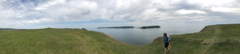
5th May 2017Colwyn Bay to Llandudno – 12.2 miles of coastal path and again the weather was glorious. Little Orme, an incident with Sharon on/off the bike, the smallest church in the UK, Llandudno pier, and then around Great Orme.
6th May 2017Llandudno to Llanfairfechan – 12.1 miles where we chose the “flat” route. We had sand dunes, Conwy Castle, the smallest house in Britain, a scary route besides the motorway (with lorries 1 metre away from us) and our arrival in Llanfairfechan.
7th May 2017Bangor to Llanfairfechan – 10 miles from the Pier in Bangor, on a glorious day through woodland and beach, and a wild bird reserve. Then Bonnie took a dip in a lake and had to be fished out before we finished with ice cream and a snooze in the sun.
21st March 2019Caernarfon to Bangor – 10.9 miles along the Menai Strait with a lot of bike path and roads, as well as some woodland and a finish on the beach to get to the pier before it got dark.
We hope you enjoy reading about the North Wales section of the coastal path and are inspired to follow in our footsteps. There are moments of pure beauty on this part of the path, but also a lot of roads and flat parts which break up the day. 8 days seems about right and we did it in 91.2 miles all in which is a lot less than the Isle of Anglesey.
After a long walking weekend we decided on a helpful short walk before our long journey home – helpful because by doing a few miles of this 13.5 mile total walk today we can then, the next time we come up, complete this walk and 4 or 5 miles of the next walk to Trefor. Why is that important? Because that then means on the following walk we can add the optional detour of climbing Yr Eifl which is a 564m peak with fabulous views and a mile beyond that we can see an Iron age hill-fort at Tre’r Ceiri. This is getting like snooker – always thinking two walks shots/walks ahead!!
Anyway, back to today and back to Morrisons in Caernarfon again but this time we turned left not right. Almost immediately we walked around a new housing development, and found a small blue pier.
Anglesey opposite usA long walk on a short pier
The walk then took in the harbour with all it’s sail boats.
Caernarfon Harbour
And then the outside of the castle walls.
And those were really the most interesting bits of the walk today. After that it was all flat and mostly just along the coast on quite a grey day.
Anglesey to the right of us
Ahead of us was the Caenarfon airfield and Aviation museum on the penisular, across the other side of the Y Foryd.
You can just make out the airfield
But in order to get over the river Afon Gwyrfai we had to head in land for a mile to get over a bridge.
Here is where we have to leave the coastAnd by the time we get inland a mile this is all that the river looks like
We had planned to try to get to Dinan Dinlle and then get the bus back to Caernarfon, but with the buses only every 90 minutes we decided to stop at the Saron bus stop and head back. Well it was either another 2 miles of walking and a 50 minute wait or head back now and get coffee and cake. And coffee and cake always wins. So we stopped at Saron for today and will pick up from there another day.
And what a view to look at while eating lunch
Only 5 miles today, but that makes 54 miles over the whole weekend. And we have got below 400 miles to go now – 475.8 miles completed and 399.4 miles to go. Time to hang up the shoes until our next walking weekend in May.
After Saturday’s long walk we decided to have a rest day on Sunday (well my feet decided it really) so instead we ……went for a walk in a forest hunting red squirrels (and found only one). Well it wasn’t a coastal path walk at least, although that didn’t make much difference to the feet.
But Monday was a new day and the feet felt up to doing a walk again, so after planning various options and changing our minds we decided on around 12 miles of walking from Amlwch to Moelfre which had the advantage of being the next walk in the book and kept the flow going nicely around Anglesey in an anti-clockwise direction. So we drove to Moelfre, parked up and got the bus to Amlwch. At the bus stop we met the same people we had seen on 2 previous days – they were getting off the bus at Moelfre and walking back to Amlwch, so we knew we would see them again at some point in the day provided we didn’t get lost.
The bus at Amlwch left us with a short walk to the port, our starting point, and the first task of the walk was to undertake the obstacle course.
The warm-up
The path then took us around the edge of the port…
Amlwch port
After the port the walk soon changed to one of rugged coast line with outcrops ahead of us to aim for.
Traditional Coastal Path viewHead for the lighthouse
The first landmark in site was the Trwyn Eilian Lighthouse, which actually looked like a regular house from the back. But first there were more hills and streams to cross.
On the way to the lighthouseEilian
Just before Porth Eilian is an ancient well called Ffynnon Eilian.
The plague is more noticeable than the well itselfA little statue on the site of the well
And then up the other side of the hill via some steps.
Yes up here!!
But the climb was worth it when you get this sort of a view.
Stunning views on another beautiful day
Porth Eilian
We didn’t detour off the path to go up to the lighthouse as we weren’t sure if it was even open.
The closest we got to the lighthouseAnd as we walked away from it
The next landmark to aim for was Ynys Dulas, which is a very small island just off the coast. Legend has it that the Lady of Llysdulas Hall used to row out to the island and leave food, so that when sailors got shipwrecked on the island they could eat. Unfortunately the current owners of Llysdulas Hall aren’t quite so obliging and the coastal path had to take a detour inland across some fields at this point to avoid going across their land.
This bridge was being built as we crossed itAcross the field with lots of lambs – these were the cutest onesThis house had a lovely garden with a pond and stream through it – Sharon was getting ideas!!
After crossing the fields we met the walkers from the bus this morning – they had got further than us, but they did have a head start. With hindsight the rest of the walk proved to be flatter than the part we had completed as well. We shared a few stories of our parts of the walk and said our farewells – they had already completed the whole of the mainland Wales coastal path and just had Anglesey to go during a 2 week holiday.
A road took us down to Dulas Bay – and although the other side of the Bay was tantalisingly close we knew we had to go inland across the marshland again to get around the bay.
Dulas BayWhere we needed to get toA shipwreck in the BayBut round it we must walk
The Bay narrowed enough for a bridge to get us over the river which feeds it “Afon Goch”, and by now we had eaten all our rations and were looking for food.
Afon Goch
We found a pub on the hill (the Pilot Boat Inn), but unfortunately it was closed, so we used their picnic bench as a chance to change our socks and drink the last of our coffees.
We couldn’t even get on the fun bus!!
Then up the hill past the sheep and we came to Traeth yr Ora, not sure if is related to Rita Ora?
Up we go with some sheep leading the wayLooking back across the bayTraeth yr OraWe then headed past Craig-ddu
After some smaller hills the path took us down onto the beach, Traeth Lligwy, and hope of some food at the cafe.
But unfortunately the cafe was closed and being painted.
Will we ever get food?
The lifeboat station came into view, and then the lifeboat cafe, but at 4.28pm it had shut 2 minutes early.
The lifeboat station
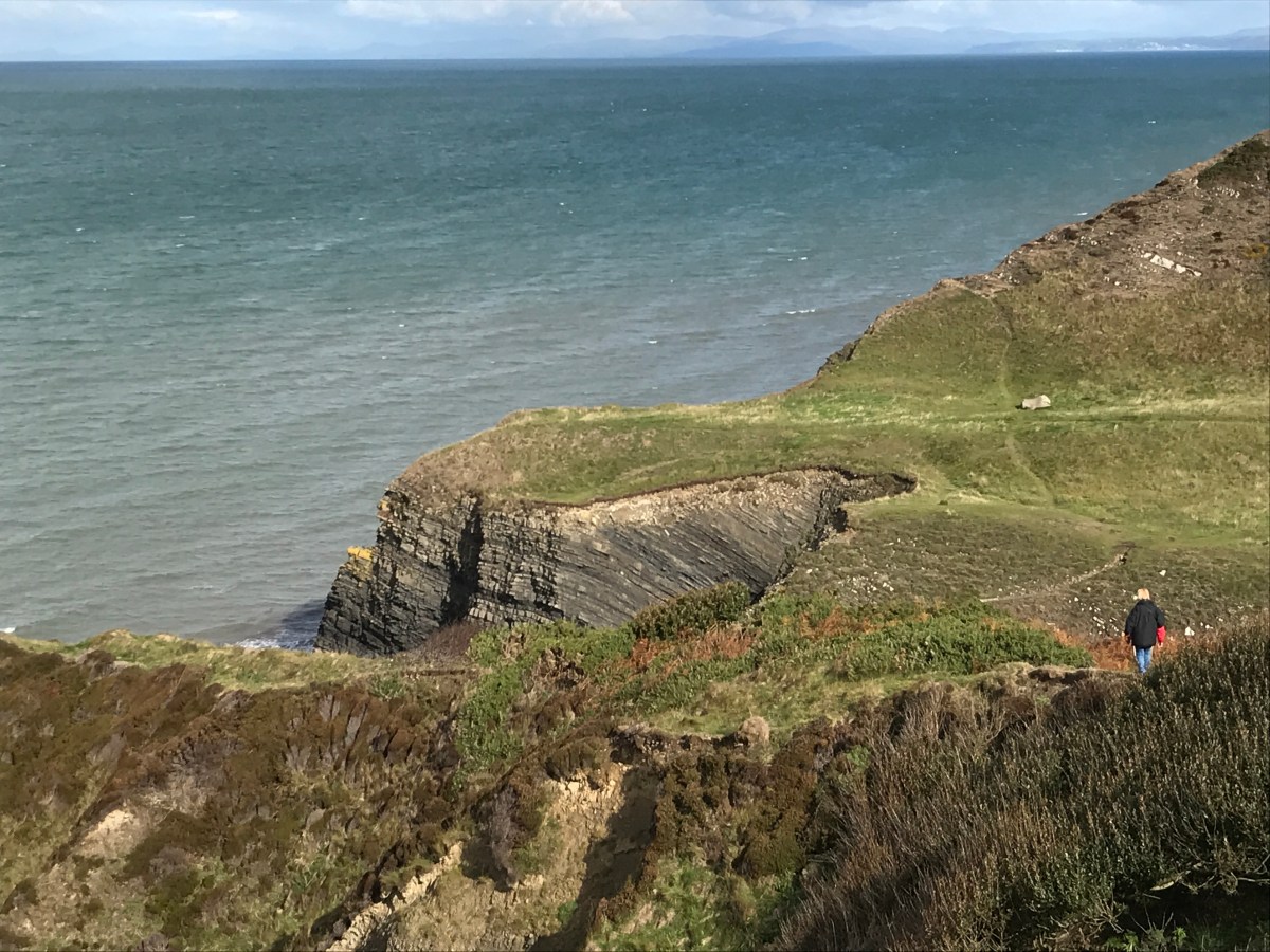
The coastline around here had large steps in places, which are man made due to extensive quarrying of the limestone directly from the cliffs. This area is also famous for the Royal Charter passenger clipper which was shipwrecked here on its way back from Australia in 1859. 459 people lost their lives, only 40 survived and large amounts of gold were recovered on the beach from passengers returning with personal hoards from the gold mines.
A Royal Charter memorial
We rounded the corner and there was the end point to our walk in the Porth Moelfre.
Our end pointProof of the sign
And there was a pub in the Port, no food being served for an hour but at least we got a very nice coffee, and they were dog friendly for Bonnie as well. So well done to the Kinmel Arms for being so friendly and welcoming.
And that was our walk. 12.9 miles completed today and 1308 feet of height, at a very slow 6 hours and 21 minutes, but that was always going to be the case with my blisters. This takes our total up to 470.8 miles completed and 404.4 miles to go. A short walk tomorrow before we head for home.
Day 3 of our walking long weekend, and today was the longest day of the weekend. Our walking bible put the walk at 14.5 miles, so we allowed all day for it at a gradual pace. Unfortunately, having parked at Llanddona, we again had the walk up the steep hill to the bus stop before we could even get going.
Up we go againThe tide is out now, so this shows that we could have cut a lot off yesterday’s walk if we had timed it right
Bonnie seemed to enjoy the bus ride today:
We got off the bus on the mainland side of the bridge, so that we could walk back across the Menai Suspension Bridge as part of the day. Built by Thomas Telford and completed in 1826, the bridge was designed for horse and cart, and was used to bring cattle across to the mainland for sale – before the bridge they had to be swum across the Menai Strait.
The arches on the bridge just fit a bus through, but I wouldn’t fancy that route day in and day out.
On to the bridgeThe view from on the bridgeHere goes a bus through the arch
The coastal path then dropped down the hill leaving the bridge behind us.
There are 4 small islands in the Menai Strait but from this side you could see that one was connected to Anglesey by a bridge.
After a mile or so the path turned left up a steep road, and away from the coast. For the next few miles there was no path by the waters edge and no pavement on the coastal road, so the coastal path took a ‘high ground’ route, giving great views of Snowdonia.
Snowdonia across the other side of the Menai Strait
Our coffee stop with a view
After some “debate” about whether to walk through a swampy field as per the coastal path sign or to take a slightly longer route along the road (the road won) we started the descent into Beaumaris and it’s colourful houses.
The tide was high at this point, and up against the sea wall.
The sea wall at BeaumarisViews across to Bangor and beyond it Great Orme
We stopped in Beaumaris for a nice coffee and cake at Jolly’s coffee House and Patisserie. Highly recommended for lovely fresh cakes, and an amazing bank vault in the basement. We will be returning to Anglesey just to spend time looking around the castle and enjoying the lovely shops and eateries of Beaumaris. But for today, suitably refreshed, we headed past Beaumaris Castle (the castle was never finished as it was built too late during the conquest of Wales) and along the road for a short section as the path was closed for drainage works.
Beaumaris Castle
And then back along the shoreline around Friars Bay till we came to a sign….
Along the shore of Friars BayThe weather was stunning for March
The sign said that at high tide we should head inland, but if we were more than an hour either side of high tide we could go along the beach. We were definitely more than an hour past high tide and the tide was going out so we decided to chance it. The first part was a lot of rock climbing.
Over we go
We had to climb over, and under, a few fallen trees, and then we came to a point where there was a rocky outcrop and no way over it, so off came the shoes and socks (and in Andrew’s case the trousers as well as he couldn’t roll the legs up) and we waded around the first rock, only to find a second one, so the wading continued after our freezing toes had braved the stony beach …….ouch ouch ouch ouch.
Have to go around itWait for me, and look at those legs 🙂
We dried off our feet and got dressed, only to see that in those 10 minutes the tide had gone out far enough that we could have walked around the rocks without getting wet – you have to laugh – or cry!!
What a difference 10 minutes makes
The coastal path was then a mixture of road and coast up to Porth Penmon.
Suddenly in front of us was a series of buildings which make up Pemmon Priory Church. There is a pigeon loft of the grandest design, Abbey ruins, a church and a well. All founded by St Seiriol.
The abbey building
Inside the churchThe ancient wellEach stone hole housed a pigeon
If you wanted to drive to the lighthouse the next part was a toll road, but we were walking so it was free.
Trwyn Du Lighthouse
Beyond Trwyn Du Lighthouse was the island of Priestholm, also known as Puffin Island, where St Seiriol set up a monastry in the 6th century which was accessible at low tide. Apparently the puffins were wiped out by rats in the 19th Century and today it is protected for the cormorant colony.
After a refreshing coffee at the lighthouse cafe we continued around the coast. According to our book the end was almost in sight now, and the coastal path should have headed inland to cut off quite a bit of the corner. But unknown to us they had decided to move the path right up against the coast, adding an extra mile or more to an already very long wall.
The yellow line should be the coastal path, but the blue dot shows us, on the new coastal path
We had various paths, fields and then marshland to navigate across and by now it was gone 5pm and starting to get cold.
Mudglorious mud
Here are various pictures of us walking across fields, and by now Bonnie was very tired and refusing to walk any further so we took turns carrying her.
Family photo time
A steep descent followed to get to the beach and at around 6.30pm we made it to LLanddona beach.
Down we goTo the beachAlmost there
Finally we hobbled to the bridge and the end point – with the car just a few more steps away.
Our finish sign
So today was a massive walk. 16.6 miles and over 1,470 feet of elevation.
The running total is now 457.9 miles completed and 417.3 miles to go. A rest day tomorrow to let the feet recover, and then hopefully two more days of walking if we are up to it.
Day two of our walking weekend, and our first adventures onto Anglesey. Llandona is going to become a familiar sight to us as it will be the start and end point for two of our walks. With free parking by the beach it is very convenient….slightly less convenient is the walk of almost 1 mile up a very steep lane to get back to the bus stop. It is a 30% gradient in places and this picture doesn’t do it justice!!
You can’t quite get the feel for how steep this hill is!!
But up we went and on the bus back to the Menai Bridge and then on a connecting bus to Moelfre to start our walk. We deliberately picked a shorter walk today as there was heavy rain forecast for around 2pm, and with a 9.15am bus, and arrival in Moelfre at 10am, anything more than around 9 miles will mean we get very wet.
Moelfre is a quaint village on the coast, with quite a history, but more of that on Monday’s walk. For today we had to set off straight-away, leaving the small stony beach behind.
Moelfre beach
The walk started by heading up from the village and along the cliff top across some fields.
This house is on the coastal path and you have to walk through their garden – it would make a great site for a tea-roomLooking back to Moelfre
The path then cut across more fields below a caravan site (and I suspect the field will be a touring field for tents and caravans in summer), and you can just make out a rogue static van which has been positioned right on the cliff-top.
The first shingle beach then came into view at Traeth Bychan.
Traeth Bychan
The path then followed the coast line precisely, right down to Benllech, which is a sandy beach area (when the tide is out; when the tide is in it is just water) with a small beach hut cafe.
The markers to follow on Anglesey
On Anglesey the familiar coastal path sign is often replaced by the Isle of Anglesey Coastal Path sign.
After a hot chocolate and freshly fried donuts….
Sharon enjoys the fresh donuts
we continued the walk, slightly inland, through a car park and up a hill. When the path continued down a road and seemed to hit a dead-end with just the sea ahead of us we started to get a bit worried. Just then a post van pulled up so we asked the postman where we were supposed to go, and he pointed through the water and around the corner. So our rock climbing skills were well tested – fall in and it would be wet feet for the rest of the walk.
Here goes Spider WomanWill Sharon make it?
Once we rounded the corner we were faced with a couple of pubs and restaurants at Red Wharf Bay, followed by a lot of soggy marshland and the need to walk right around the edge to our end point. Although it looked like the usual estuary that we have to walk around, it was actually just the sea reaching an inland area and, if we had waited long enough, the tide would have gone out and we could have cut 2 or 3 miles off the journey. But time was not on our side, so we braved the marshland and a few more rock climbs to get around.
Dodging the puddles
Then we hit upon the beach, and the option of heading inland through woodland or walking along the beach – as the tide was receding faster than Andrew’s hair we went for the beach option, which would be fine most of the time unless it was a very high tide.
Traeth Coch
Suddenly the beach ended and we had to go up 5 or 6 steps onto a narrow wall, and the coastal path then led across the top of the wall for about a mile. This needed a good sense of balance (something Andrew isn’t known for) and concentration.
Andrew showing off on the wallThe never ending wall
With the storm clouds overhead, and the clock on 2pm we made it to the road leading past the car park and toilets at Llandona beach.
The beach road
And to the end point for today at a bridge leading back up the other side and off the beach.
We made it, and before the rain
9.1 miles completed today in 3 3/4 hours. Only 469 feet of height so quite a flat day really. our total is now 450.9 miles completed, and 424.3 miles to go. Tomorrow sees the killer walk of the weekend, but already the blisters are growing.
Our first walking weekend of 2019 – and a series of landmarks today for us. This walk is the prelude to our first weekend of walking on Anglesey. It is also the last walk in the North Wales section of the book, and the walk which takes us over half-way around the coastal path of Wales.
After a 4 hour drive to get here we were raring to go as and parked in Bangor and got the bus to Morissons in Caernarfon to start the walk. The entire walk today is along the one side of the Menai Strait, past both bridges and to the Pier in Bangor to join up with this walk. The first few miles of the walk followed the bike path so were flat and easy.
Our starting point which follows the bike path
The tide was on it’s way out and the Menai Strait looked calm, if rather cloudy.
The long and flat bike path
We then headed through a boat yard at Port Dinorwic and across a small bridge to a new part of the coastal path which has not long been open.
Some lovely views of AngleseyThe boat yardBonnie balancing herself along the wallThe bridge, which could easily be missed
The walk then turned to woodland and up a hill.
And then we went through the Faenol Hall estate, and our first mistake of the weekend. We went straight across a field of sheep rather than behind a fence along the edge. We only realised this when we spotted a walker behind the fence, and decided to climb the fence to join the path – only for the path to then go through a gate and back into the field we had just left!!
Sounds like an ad break
And then the first Menai bridge came into view – Pont Britannia, the newer bridge which lorries can use. I say newer but it was built in the 1850 as a rail bridge but after a fire in 1970 it was remodeled to take vehicles.
Pont BritanniaCars and lorries go across the 2nd layer
Then a series of small islands came into view in the Menai Strait – and although they were very pretty houses, the noise from the roads must be rather annoying.
Another wood then followed through Treborth Hall.
Bonnie takes the lead through the wood
And then the original Menai Suspension Bridge (built in 1826) came into view, and this one we had to walk up to rather than under. More on the Menai bridge later in the weekend when we cross it.
Menai Bridge comes into viewA bus tackles the archesA majestic bridge
After a further section of flat walking along the A487 the path turned left and went past Bangor football ground (a free game if a match is on), and then over a series of stepped ups and downs through woodlands at Nant-Porth.
As it was now low tide we were able to walk along the shore towards the pier and our end point.
The end is in sight
And Sharon was not hanging around.
A small boat yard which we used to cut back up to the road
And then we arrived at the pier: deliberately an easy first day as we couldn’t start till 1pm. And again we couldn’t go onto the pier because we had Bonnie with us.
Our end point
Unfortunately at this point Sharon’s phone died – unfortunate for her as her bus pass was on the screen, so I got the bus back to the car and met Sharon at the supermarket once she had bought the items we had forgotten to pack.
So today was 10.9 miles in 3 and a half hours, with 653 feet of height. More importantly it takes us to 441.8 miles completed and 433.4 miles to go – whoooo we’re half way there, and after only 3 years and 3 months.
Day two of our double-header, and I make no apology that today will be full of photographs, as this has to be one of the most stunning sections of coastal path. It needs to be though or people wouldn’t attempt it, as it is single day with the biggest climbs of any – over 780 metres if the guide book is to be believed.
So we are planning for this walk to take all day, and Bethan arrived at 9.15 to get us to the start point (thank you Bethan again). The early start is OK though as I have been promised breakfast when we get to Tresaith. I am not sure how Bonnie’s little legs will cope with all the hills today either.
Looking down on Aberporth
The first part of the walk is on a new tarmac path, and you walk past several houses which have been converted from train carriages – explains why we couldn’t get a train to our start point today!!
A carriage with a view
The walk was already teasing us with the views ahead of us.
Just a part of what is still ahead of us today
We arrived at Tresaith at just after 10, only to find the cafe shut and the only pub stopped serving breakfast at 10.
Tresaith ahead of us
So we soldiered on up the hill out of Tresaith, and towards Penbryn Beach.
Penbryn BeachThe view behind us and the hill we were walking up
Penbryn also took us in land slightly to get past a river, and we decided to stop in the wooded glen, complete with ferns, to have our breakfast – which was actually half of our lunch (a bit early).
A waterfall by breakfast
We then climbed up the other side of the wood and found ourselves in a National Trust car park, complete with a tea room. The air did turn rather blue at this point!!
This tea-room looks nice – if doing this route then make sure you plan a visit to it!!
The views behind us got better and better as we got higher and higher.
And ahead of us now was Carreg-y-ty with it’s sandy cove.
Bonnie leads the way to Carreg-y-tyCome on in, the water looks lovely
It looks like there is a little door inside
The view ahead then got better still as we approached Ynys Lochtyn, which is used as the main picture to advertise the Ceredigion coastal path.
The next landmark on the way to Ynys Lochtyn was Llangrannog, the village rather than the activity centre that kids stay in. We had been told of a lovely coffee shop on the sea front, and it didn’t disappoint. At this point we were 5 miles in and around 120 flights of stairs, so we still had a way to go.
LlangrannogSharon makes friends with St Carannog who founded the first church in the areaThe beach at LlangrannogA close up of Ynys Lochtyn
The coast line ahead still showed a lot of undulations, with Cwmtydu now the distant part.
One last glimpse back to Ynys Lochtyn
And then out of no-where comes the Llangrannog activity centre with ski slope and go karts
The climbs seemed to get steeper and steeper, and New Quay still wasn’t in sight, and ahead was the worst climb of them all, cut into the hill side.
You can just make out the path ahead of us
And then, not since our first walk nearly 4 years ago in Chepstow, Sharon once again uttered the famous words “That’s a pretty sheep”. And, to be fair, it was.
Who’s a pretty girl then
The next big drop through a forest took us into Cwmtydu, and a welcome, if somewhat expensive ice-cream stop
It’s a long way down
We didn’t have time to stop at the tractor tableIce-cream on the go for usSome sort of smuggler cave maybe at Cwmtydu
We still had a massive climb to go, and then from the top the view looked like this, where is New Quay?
Another descent followed, and on a bridge in the middle of no-where was this….
A bit late!!
I could have done with that a few hours earlier!!
Our final climbSharon and Bonnie lagging behind, and Sharon looks like she is puffing a bit
After all the dangerous walking it was a surprise to see this warning sign right at the end, but we did follow the safer route.
Which finally gave us a glimpse of New Quay
New Quay over the hedgeThe harbour wall
What a welcome sight that was and what a view
The route then took us down through the town, past houses, and the harbour, ending our day with the walk out of New Quay to the caravan site.
And we are back home
Strava records it as 14.6 miles and 4,148 feet of height (which is 1,264 metres). This is higher than walking up Snowdon.
What a bumpy ride
And that was our weekend done – 27.2 miles in total, making a grand total of 430.9 miles walked and 443.3 miles to go. One more day of walking and we should be halfway around the coast.
Our last walking weekend of the year – and also our first since May (which is very remiss) and we got off to a delayed start as the weather was so bad on Friday and on Saturday morning, so only 2 walks this weekend, but they will have lovely scenery.
Today we are walking the 13 or so miles from New Quay (where we have hired a static caravan) to Llanrhystud to join up with this previous walk. We chose this way as it is relatively flat (compared with the walk we are saving for tomorrow) and we should be able to complete it in an afternoon rather than having an all-day adventure.
You can see the sea from our caravan!
We headed down to the beach and walked along till a river meant we had to head inland.
The view back to New QuayNew Quay beach below Quay West Haven park
The view even further back towards New QuayThe hills ahead of us
Some stunning landscape around Craig DduThe beach below Cwm Clifforch
And before we knew it our lunch-spot of Aberaeron was right in front of us.
The coastal path led down, through a forest, over a bridge and past an orange roman style house, complete with horse statue in the garden, to the town of Aberaeron.
It’s not movingSharon is not afraid of heights
We met up with Bethan (our taxi driver for later as buses are infrequent) and bribed her with pancakes and nutella, and then set off around the lovely harbour and back to our walking.
The walk now was mostly flat for the rest of the afternoon, which was exactly what we needed to keep the pace up and get to the end before 5.30.
That’ll be us
Just before Llanon we got a little bit lost and had to ask for directions. The alternate Blue route goes in land to Llanon itself to get over the river, but the red route allows for you to do a bit of stepping stones (I did OK!!) over the river and then walk along the beach to the second tower and then the paths rejoin.
The tower to get off the beach
At this point we stopped to collect some driftwood for future projects, but it did look more like Sharon had been to the bakery!!
Baguettes anyone?
We then had to weave through the small town of LLansantffraed, and over a bridge next to the church of St Brides before heading past four old lime kilns, used historically to burn limestone to spread on the fields to make them more fertile and improve drainage.
Lime Kilns
Then a stop for a coffee and cake on the beach watching the waves hit the shore from the strong wind….
and then the coastal path takes you up a long straight road towards the main road.
It’s me again – but look at that sky
And you arrive at the entrance to the campsite which marked the end of the previous walk.
The coastal path would then head back into the camp site and up the hills to Aberystwyth, but for us that is the end of the day, and a moment to relax before Bethan arrives to take us back to the campsite. 12.6 miles in total and around 450 metres of height gained today. Time for dinner before tomorrow’s adventures.
This is a double-header update to cover the walks both sides of Tenby.
On the Saturday we set off early from home and drove to Amroth, parking right on the seafront with free parking. We were also only 10 metres from the bus stop, so today will count as the day with least extra “non-coastal path” walking.
After a delicious “Pirate” breakfast we got the bus to Tenby, and that was quite a scary ride down some narrow lanes.
The bus heading along Amroth front towards us
And off we set from Tenby for the walk – the coastal path isn’t signposted at all through Tenby so you just make your way through the town and down to the harbour and North beach.
St Catherine’s Island
A view of North Beach
A beautiful day on North Beach
The coastal path then rises sharply firstly along a road and then through some fields.
An optional loop
Complete with wooden carvings
And a good path
The path then stays quite high for a while with views of the coast through hedges and trees before dropping down to sea-level in a little cove just before Sandersfoot. We stopped for a coffee and Sharon decided to have a paddle in the very cold water.
The tide was in too far to walk around the coast on the beach, so we climbed back up to continue the walk to Saundersfoot.
And after a surprisingly short stop for shopping we headed out of Saundersfoot in the glorious sunshine and through a tunnel, yes a tunnel, to get to Coppet Hall Point.
One of the two tunnels
After a suntan lotion stop we went through a second tunnel and along a very well walked part of the path to Wiseman’s bridge. By now the tide was well on the way out, and we were able to walk from Wiseman’s bridge all the way to Amroth on the beach over rocks.
Wiseman’s bridge
Over the rocks we go
What a lovely beach when the tide is out
Time for another paddle
And there was the car – so a lovely stroll of 7.6 miles and we had joined up to our previous Laugharne to Amroth walk.
After a great evening in St Florence and a good pub meal we set off the next morning for day 2 – parking in Tenby and getting the train out to Lamphey – which is about as close to the coastal path as we could get to start today.
By “close” I mean about 2.5 miles of walking to get to the coastal path, most of it along a road, so not the most exciting of starts, but at least we had some cloud cover today to stop it being so warm. And after a steep descent we made it to the start point by Freshwater East beach.
Our start point
Bonnie near the beach
The coastal path heads behind the beach through dunes, and then sharply up a steep climb to get to West Moor Cliff; the views here are mainly behind us back towards Freshwater East.
Ahead of us though from this height Sharon kindly pointed out our future path around Swanlake Bay, and it was a big drop and rise again…..
The bay ahead of us
Sharon kindly showing our path
A very peaceful beach – not surprising given how difficult it is to get to it
The climb up East Moor Cliff was a big one, and to then turn the corner and see another drop down, this time into Manorbier Bay was a little disheartening, but the views along here were magnificent because of the height.
Approaching Manorbier Bay
We stopped for lunch at Manorbier Bay, but didn’t have time to see the castle. Then off we set again up Priest’s nose this time, and if you look closely you can see fishermen sitting in very precarious positions on the rocks below us.
Fishermen
A rather large crack beside the path
Another climb ahead of us
We then climbed up and around Presipe Bay, where thankfully we didn’t have to drop down to the beach for once – although Alice and her family had done.
The path then has to turn inland to avoid Manorbier firing range, and there were some neat dog openings on the stiles. It was also a chance for the pace to pick up on some concrete paths.
Then suddenly Caldey Island came into view, and from an angle that we had never seen before.
Caldey Island
Then once more we dropped a fair distance towards Skrinkle Haven, but this time the way back up was steps, and lots of them. Andrew decided to tackle them in one, and then needed a 5 minute sit down to regain his breath.
The steps before we dropped down to them
The steps in front of us
Then it was quite a surprise to come out besides some caravans on the Haven Lydstep site, and we got a bit lost navigating our way around the caravans, but Sharon got us back on track, even if it was a very much unused track with lots of stinging nettles.
A prime position for a caravanLydstep bayOvergrown pathsSharon steams ahead – must need food!!
After Lydstep the path heads up again to Penally, and with the red flag down we were able to walk across the shooting range, and past the trenches used to train soldiers in WW1.
Looking back to Lydstep
Limestone rocks
We then arrived at Giltar Point, but were not feeling brave enough to climb out on it – hard to believe that this beautiful spot is so close to Tenby South Beach, and gives such good views of Caldey Island.
Giltar Point
Caldey Island
Then we headed through a beautiful small wood and arrived at South Beach.
Who knew this wood existed?
South Beach
Looking back to where we have come from
And we were back in Tenby – so a lot longer day than yesterday – around 6 hours of walking, a total of 15 miles, and over 210 storeys of height. But for the coastal path it was 11.7 miles completed.
So with 19.3 miles completed this weekend our grand total is now above the 400 miles completed mark at 403.7 miles, and 470.5 miles to go. 3 walks away from being halfway!!
The final day of the weekend, and we decided to go for it- a full day of 11 miles before we headed home, mainly so that we leave a single walk north from our New Quay base when we return in October.
So we packed up and left Borth at 8am. We parked the car at Llanrhystud and got a bus back to Aberystwyth. After a breakfast in Greggs we headed back to the pier. Just along the sea front was Aberystwyth castle so we stopped for a nose.
Aberystwyth castle
The view from the castle
The coastal path then takes an inland turn to cross Avon Rheidol before heading past the harbour and along the sea wall.
Aberystwyth harbour
Then our first decision of the day, the coastal path stays on cliff tops all day, but our guidebook says that at low tide you can walk along the beach for that true coastal experience. The tide was certainly low(ish) but on its way in, so we decided to start on the beach and then head up once we got cut off.
By going on the beach we avoid this rather large hill
Now this sounds a great plan, but there were two problems with it….firstly the beach was mainly covered in large rocks and slate dropped from the cliff above so was very slow to navigate. Secondly after about 3 miles of this it was becoming clear that the coastal path was not dropping down to the beach any time soon.
Slate outcropsFallen from aboveSome amazing rock formationsSharon and Bonnie navigate the rocks
And then the dilemma; we saw a set of steps through a campsite to get us off the beach and up onto the cliffs, or we could risk there being another exit on the beach further down before the tide comes in. We chickened out and left the beach for a steep climb, and further on we were fully justified as the beach was completely cut off.
Exit point, and the sign was a bit late to warn us!
The cliff tops were the usual mix of fields of sheep and steep climbs.
Another steep climbSheepy fieldsA very picturesque pointSo far we could have made it on the beach
The path was blocked by a fallen bush but we climbed that and continued with the clouds heading in. The buzzards started circling overhead!!
Clear the way please SharonOne of many buzzards
At Penderi cliffs there was a nature reserve but it looked rather dangerous to try to get to judging by the sign.
Head first as well
The path then hugged the side of a steep cliff and was dangerous in places but the sheep seemed to cope.
On the side of a steep cliffHold on SharonWe made the right choice, there is no way we would be walking along the beach there
Finally the path dropped down to a campsite and then along a road and before we knew it we were back by the car.
Caravan park in the distanceCaravan park close upThe end of the walk and the end of the weekend
For those who like statistics, and who doesn’t…..today was 11.3 miles in 4 1/2 hours, and 155 storeys. So this weekend was 46.1 miles in total. Our total distance walked is now 384.8 miles and 489.9 miles to go. Another 53 miles and we will be half way!!


 You can see the sea from our caravan!